
Carte topographique Shankharapur
Carte interactive
Cliquez sur la carte pour afficher l’altitude.
À propos de cette carte
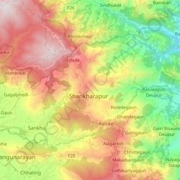
Nom : Carte topographique Shankharapur, altitude, relief.
Lieu : Shankharapur, Kathmandu, Bagmati Province, Nepal (27.71599 85.42901 27.79259 85.56596)
Altitude moyenne : 1 520 m
Altitude minimum : 767 m
Altitude maximum : 2 420 m
Autres cartes topographiques
Cliquez sur une carte pour visualiser sa topographie, son altitude et son relief.
Budhanilkantha
Nepal > Bagmati Province > Kathmandu
Budhanilkantha, Budhanilkantha Municipality, Kathmandu, Bagmati Province, 22644, Nepal
Altitude moyenne : 1 665 m
Budhanilkantha Municipality
Nepal > Bagmati Province > Kathmandu
Budhanilkantha Municipality, Kathmandu, Bagmati Province, Nepal
Altitude moyenne : 1 589 m
Namgyal
Nepal > Bagmati Province > Kathmandu
Namgyal, Gokarneshwar Municipality, Kathmandu, Bagmati Province, 46603, Nepal
Altitude moyenne : 1 366 m
Kathmandu
Nepal > Bagmati Province > Kathmandu
Kathmandu, Kathmandu Metropolitan City, Kathmandu, Bagmati Province, 46000, Nepal
Altitude moyenne : 1 538 m
Tokha
Nepal > Bagmati Province > Kathmandu
Tokha, Tokha Municipality, Kathmandu, Bagmati Province, 44607, Nepal
Altitude moyenne : 1 366 m