
Carte topographique Greater Hyderabad Municipal Corporation South Zone
Carte interactive
Cliquez sur la carte pour afficher l’altitude.
À propos de cette carte
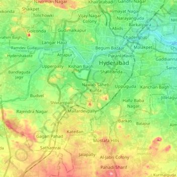
Nom : Carte topographique Greater Hyderabad Municipal Corporation South Zone, altitude, relief.
Altitude moyenne : 535 m
Altitude minimum : 471 m
Altitude maximum : 649 m
Autres cartes topographiques
Cliquez sur une carte pour visualiser sa topographie, son altitude et son relief.
Ward 4 Meerpet H.B Colony
Ward 4 Meerpet H.B Colony, Hyderabad, Uppal mandal, Medchal–Malkajgiri, Telangana, 500040, India
Altitude moyenne : 541 m
Ward 105 Gachibowli
Ward 105 Gachibowli, Greater Hyderabad Municipal Corporation West Zone, Hyderabad, Rangareddy, Telangana, India
Altitude moyenne : 568 m
Ward 106 Serilingampally
Ward 106 Serilingampally, Greater Hyderabad Municipal Corporation West Zone, Hyderabad, Rangareddy, Telangana, India
Altitude moyenne : 588 m
Ward 7 Chilka Nagar
Ward 7 Chilka Nagar, Greater Hyderabad Municipal Corporation East Zone, Hyderabad, Medchal–Malkajgiri, Telangana, India
Altitude moyenne : 498 m