
Carte topographique Friesoythe
Carte interactive
Cliquez sur la carte pour afficher l’altitude.
À propos de cette carte
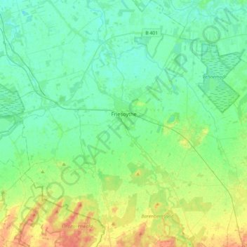
Nom : Carte topographique Friesoythe, altitude, relief.
Lieu : Friesoythe, Cloppenburg district, Lower Saxony, 26169, Germany (52.90434 7.70359 53.11977 7.96121)
Altitude moyenne : 13 m
Altitude minimum : 1 m
Altitude maximum : 45 m
Autres cartes topographiques
Cliquez sur une carte pour visualiser sa topographie, son altitude et son relief.
Saterland - Seelterlound
Germany > Lower Saxony > Cloppenburg district
Saterland - Seelterlound, Cloppenburg district, Lower Saxony, 26683, Germany
Altitude moyenne : 5 m
Saterland - Seelterlound
Germany > Lower Saxony > Cloppenburg district > Saterland - Seelterlound > Saterland - Seelterlound
Saterland - Seelterlound, Cloppenburg district, Lower Saxony, 26683, Germany
Altitude moyenne : 6 m