
Carte topographique Pantai Puteri Dewi
Carte interactive
Cliquez sur la carte pour afficher l’altitude.
À propos de cette carte
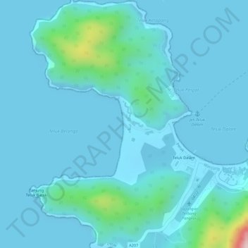
Nom : Carte topographique Pantai Puteri Dewi, altitude, relief.
Altitude moyenne : 29 m
Altitude minimum : 0 m
Altitude maximum : 281 m
Autres cartes topographiques
Cliquez sur une carte pour visualiser sa topographie, son altitude et son relief.
Pangkor Island
Malaysia > Perak > Pangkor Island
Pangkor Island, Manjung, Perak, 32300, Malaysia
Altitude moyenne : 26 m
Coral Island
Malaysia > Perak > Pangkor Island
Coral Island, A207, Teluk Nipah, Pangkor Island, Perak, 32300, Malaysia
Altitude moyenne : 22 m
Teluk Ketapang Beach
Malaysia > Perak > Pangkor Island
Teluk Ketapang Beach, Jalan Pasir Bogak, Pasir Bogak, Pangkor Island, Perak, 32300, Malaysia
Altitude moyenne : 38 m