
Carte topographique Chiloquin
Carte interactive
Cliquez sur la carte pour afficher l’altitude.
À propos de cette carte
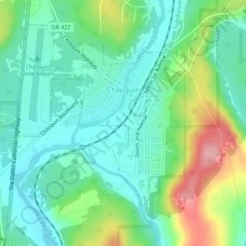
Nom : Carte topographique Chiloquin, altitude, relief.
Lieu : Chiloquin, Klamath County, Oregon, United States (42.56307 -121.88208 42.58478 -121.85693)
Altitude moyenne : 1 302 m
Altitude minimum : 1 262 m
Altitude maximum : 1 395 m
Chiloquin is at an elevation of 4,180 feet (1,270 m) in Klamath County. The city is slightly east of U.S. Route 97 and slightly north of its intersection with Oregon Route 62. A short east–west highway, Oregon Route 422, links Route 97 at Chiloquin to Route 62 slightly south of Klamath Agency. By highway, Chiloquin is about 26 miles (42 km) north of Klamath Falls and 253 miles (407 km) south of Portland.
Autres cartes topographiques
Cliquez sur une carte pour visualiser sa topographie, son altitude et son relief.
Deepest point -592m
United States > Oregon > Klamath County
Deepest point -592m, Klamath County, Oregon, United States
Altitude moyenne : 1 880 m
Link River
United States > Oregon > Klamath County > Klamath Falls
Link River, Klamath Falls, Klamath County, Oregon, United States
Altitude moyenne : 1 304 m
Crater Lake
United States > Oregon > Klamath County
Crater Lake, Klamath County, Oregon, United States
Altitude moyenne : 1 971 m
Willamette Pass
United States > Oregon > Klamath County
Willamette Pass, Klamath County, Oregon, United States
Altitude moyenne : 1 605 m
Crater Lake National Park
United States > Oregon > Klamath County
Crater Lake National Park, Klamath County, Oregon, 97604, United States
Altitude moyenne : 1 726 m
Klamath Falls
United States > Oregon > Klamath County
Klamath Falls, Klamath County, Oregon, 97601, United States
Altitude moyenne : 1 312 m