
Carte topographique Culham
Carte interactive
Cliquez sur la carte pour afficher l’altitude.
À propos de cette carte
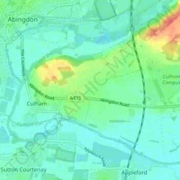
Nom : Carte topographique Culham, altitude, relief.
Altitude moyenne : 56 m
Altitude minimum : 44 m
Altitude maximum : 92 m
Autres cartes topographiques
Cliquez sur une carte pour visualiser sa topographie, son altitude et son relief.
Ochre Pits
United Kingdom > England > Oxfordshire > South Oxfordshire > Horspath
Ochre Pits, Forest Hill with Shotover, Horspath, South Oxfordshire, Oxfordshire, South East England, England, United Kingdom
Altitude moyenne : 114 m
Berrick Salome
United Kingdom > England > Oxfordshire > South Oxfordshire > Berrick Salome
Berrick Salome, South Oxfordshire, Oxfordshire, South East England, England, United Kingdom
Altitude moyenne : 61 m
Henley-on-Thames
United Kingdom > England > Oxfordshire > South Oxfordshire
Henley-on-Thames, South Oxfordshire, Oxfordshire, England, RG9 2AN, United Kingdom
Altitude moyenne : 78 m