
Carte topographique Tha Muang
Carte interactive
Cliquez sur la carte pour afficher l’altitude.
À propos de cette carte
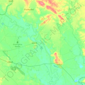
Nom : Carte topographique Tha Muang, altitude, relief.
Lieu : Tha Muang, Roi Et Province, Thailand (15.95371 103.71289 16.27371 104.03289)
Altitude moyenne : 139 m
Altitude minimum : 123 m
Altitude maximum : 180 m
Autres cartes topographiques
Cliquez sur une carte pour visualiser sa topographie, son altitude et son relief.
Ban Nong Ko
Thailand > Roi Et Province > Ban Nong Ko
Ban Nong Ko, Roi Et Province, Thailand
Altitude moyenne : 158 m
Ban Chan
Thailand > Roi Et Province > Ban Chan
Ban Chan, Roi Et Province, Thailand
Altitude moyenne : 133 m