
Faire un don
Équipez-vous pour votre prochaine aventure :
En tant que Partenaire Amazon, ce site perçoit une commission sur les achats éligibles sans surcoût pour vous.
Carte topographique Pooyamkutty
Cliquez sur la carte pour afficher l’altitude.
Faire un don
Équipez-vous pour votre prochaine aventure :
En tant que Partenaire Amazon, ce site perçoit une commission sur les achats éligibles sans surcoût pour vous.
À propos de cette carte
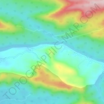
Nom : Carte topographique Pooyamkutty, altitude, relief.
Lieu : Pooyamkutty, Kothamangalam, Ernakulam District, Kerala, India (10.16351 76.74943 10.17017 76.78710)
Altitude moyenne : 129 m
Altitude minimum : 35 m
Altitude maximum : 356 m
Faire un don
Équipez-vous pour votre prochaine aventure :
En tant que Partenaire Amazon, ce site perçoit une commission sur les achats éligibles sans surcoût pour vous.
Autres cartes topographiques
Cliquez sur une carte pour visualiser sa topographie, son altitude et son relief.
Kothamangalam
India > Kerala > Kothamangalam
Kothamangalam is situated in the eastern part of the Ernakulam district. According to the division of the geographical regions of Kerala, Kothamangalam is in a mid-land region. The general topography is hilly.
Altitude moyenne : 34 m
Faire un don
Équipez-vous pour votre prochaine aventure :
En tant que Partenaire Amazon, ce site perçoit une commission sur les achats éligibles sans surcoût pour vous.
Faire un don
Équipez-vous pour votre prochaine aventure :
En tant que Partenaire Amazon, ce site perçoit une commission sur les achats éligibles sans surcoût pour vous.
Faire un don
Équipez-vous pour votre prochaine aventure :
En tant que Partenaire Amazon, ce site perçoit une commission sur les achats éligibles sans surcoût pour vous.
Edamalakkudy
India > Kerala > Kothamangalam
Edamalakudy is located at an elevation of 1100–1700 metres, 22 km north-west of Pettimudi, a village about 4 km west of the Anamudi, the tallest mountain peak in South India on the border of Ernakulam district and Idukki district. Pettimudi was hit by a landslide in 2018 and the debris have not been cleared.…
Altitude moyenne : 1 095 m
Edalipparakudy Tribal Settlement, Edamalakudy
India > Kerala > Kothamangalam
Altitude moyenne : 1 192 m
Faire un don
Équipez-vous pour votre prochaine aventure :
En tant que Partenaire Amazon, ce site perçoit une commission sur les achats éligibles sans surcoût pour vous.
Kothamangalam
India > Kerala > Kothamangalam
Kothamangalam is situated in the eastern part of the Ernakulam district. According to the division of the geographical regions of Kerala, Kothamangalam is in a mid-land region. The general topography is hilly.
Altitude moyenne : 34 m