
Carte topographique Khetri
Carte interactive
Cliquez sur la carte pour afficher l’altitude.
À propos de cette carte
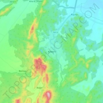
Nom : Carte topographique Khetri, altitude, relief.
Altitude moyenne : 452 m
Altitude minimum : 353 m
Altitude maximum : 747 m
Khetri is located at 27°59′N 75°48′E / 27.98°N 75.8°E / 27.98; 75.8. It has an average elevation of 484 metres (1587 feet). The name of the mountain in Khetri is Bhopalgarh.
Autres cartes topographiques
Cliquez sur une carte pour visualiser sa topographie, son altitude et son relief.
Barau
India > Rajasthan > Khetri Tehsil
Barau, Khetri Tehsil, Jhunjhunu District, Rajasthan, 333514, India
Altitude moyenne : 427 m