
Faire un don
Équipez-vous pour votre prochaine aventure :
En tant que Partenaire Amazon, ce site perçoit une commission sur les achats éligibles sans surcoût pour vous.
Carte topographique Box Canyon
Cliquez sur la carte pour afficher l’altitude.
Faire un don
Équipez-vous pour votre prochaine aventure :
En tant que Partenaire Amazon, ce site perçoit une commission sur les achats éligibles sans surcoût pour vous.
À propos de cette carte
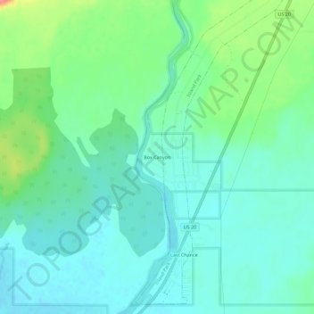
Nom : Carte topographique Box Canyon, altitude, relief.
Lieu : Box Canyon, Fremont County, Idaho, United States (44.35721 -111.42534 44.39721 -111.38534)
Altitude moyenne : 1 891 m
Altitude minimum : 1 871 m
Altitude maximum : 1 948 m
Faire un don
Équipez-vous pour votre prochaine aventure :
En tant que Partenaire Amazon, ce site perçoit une commission sur les achats éligibles sans surcoût pour vous.
Autres cartes topographiques
Cliquez sur une carte pour visualiser sa topographie, son altitude et son relief.
Newdale
United States > Idaho > Fremont County
Newdale is the nearest city to the Teton Dam, which failed on June 5, 1976. Newdale did not receive any flooding or damage, due to its elevation and position relative to the dam.
Altitude moyenne : 1 550 m
Faire un don
Équipez-vous pour votre prochaine aventure :
En tant que Partenaire Amazon, ce site perçoit une commission sur les achats éligibles sans surcoût pour vous.
Ashton
United States > Idaho > Fremont County
Seed potatoes Ashton was first and foremost a farming community, as the soil of the area is rich and the water is plentiful. Shortly after the first settlers arrived in the 1890s, several canals were developed to divert water from streams running off the Yellowstone Plateau and Teton Range. Some farmland,…
Altitude moyenne : 1 601 m
American Legion / Daughters of Utah Pioneers Park
United States > Idaho > Fremont County > St. Anthony
Altitude moyenne : 1 515 m
Faire un don
Équipez-vous pour votre prochaine aventure :
En tant que Partenaire Amazon, ce site perçoit une commission sur les achats éligibles sans surcoût pour vous.