
Carte topographique Mińsk County
Carte interactive
Cliquez sur la carte pour afficher l’altitude.
À propos de cette carte
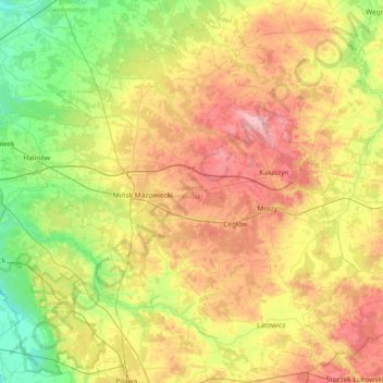
Nom : Carte topographique Mińsk County, altitude, relief.
Lieu : Mińsk County, Masovian Voivodeship, Poland (51.97357 21.23795 52.39501 21.97992)
Altitude moyenne : 143 m
Altitude minimum : 87 m
Altitude maximum : 225 m
Autres cartes topographiques
Cliquez sur une carte pour visualiser sa topographie, son altitude et son relief.
Brwinów
Poland > Masovian Voivodeship > Brwinów
Brwinów, gmina Brwinów, Pruszków County, Masovian Voivodeship, 05-840, Poland
Altitude moyenne : 97 m
Iłża
Poland > Masovian Voivodeship > Iłża
Iłża, gmina Iłża, Radom County, Masovian Voivodeship, 27-100, Poland
Altitude moyenne : 204 m
Pruszków
Poland > Masovian Voivodeship > Pruszków
Pruszków, Pruszków County, Masovian Voivodeship, Poland
Altitude moyenne : 99 m
Pruszków County
Pruszków County, Masovian Voivodeship, Poland
Altitude moyenne : 116 m
Warsaw
Poland > Masovian Voivodeship > Warsaw
Warsaw, Masovian Voivodeship, Poland
Altitude moyenne : 95 m
Praga-Południe
Poland > Masovian Voivodeship > Warsaw
Praga-Południe, Warsaw, Warszawa, Masovian Voivodeship, Poland
Altitude moyenne : 86 m
Warsaw
Poland > Masovian Voivodeship > Warsaw
Warsaw, Masovian Voivodeship, Poland
Altitude moyenne : 96 m
Radom
Poland > Masovian Voivodeship > Radom
Radom, Masovian Voivodeship, Poland
Altitude moyenne : 168 m