
Carte topographique Flughafensee
Cliquez sur la carte pour afficher l’altitude.
À propos de cette carte
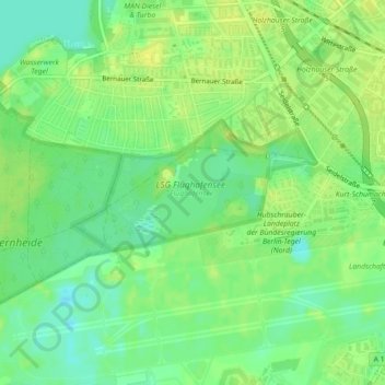
Nom : Carte topographique Flughafensee, altitude, relief.
Lieu : Flughafensee, Tegel, Reinickendorf, Berlin, Germany (52.56483 13.28129 52.57071 13.29430)
Altitude moyenne : 35 m
Altitude minimum : 25 m
Altitude maximum : 42 m
Autres cartes topographiques
Cliquez sur une carte pour visualiser sa topographie, son altitude et son relief.
Neukölln
Neukölln is on the North European Plain, which is typically characterized by low-lying marshy woodlands with a mainly flat topography. The quarter lies on the geological border between the shallow Weichselian Warsaw-Berlin Urstromtal glacial valley and the northernmost edge of the Teltow young drift ground…
Altitude moyenne : 43 m
Teufelsberg
Teufelsberg was originally thought to be 115 metres (377 ft) high, which placed it at the same elevation as Großer Müggelberg (the summit of Müggelberge), and was the highest point in West Berlin. New measurements show that Teufelsberg is actually 120.1 metres (394 ft) high, making it higher than Großer…
Altitude moyenne : 54 m
Kreuzberg
In contrast to many other areas of Berlin, which were villages before their integration into Berlin, Kreuzberg has a rather short history. It was formed on 1 October 1920 by the Greater Berlin Act, which provided for the incorporation of suburbs and the reorganisation of Berlin into twenty boroughs. The…
Altitude moyenne : 43 m