
Carte topographique Stanhope Beach
Carte interactive
Cliquez sur la carte pour afficher l’altitude.
À propos de cette carte
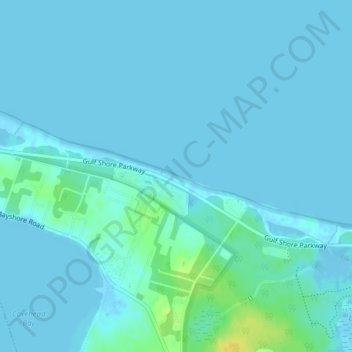
Nom : Carte topographique Stanhope Beach, altitude, relief.
Altitude moyenne : 3 m
Altitude minimum : -7 m
Altitude maximum : 22 m
Autres cartes topographiques
Cliquez sur une carte pour visualiser sa topographie, son altitude et son relief.
Stanhope Beach
Canada > Prince Edward Island > Queens County > Stanhope
Stanhope Beach, Stanhope, Rural Municipality of North Shore, Queens County, Prince Edward Island, Canada
Altitude moyenne : 3 m