
Carte topographique Bari
Carte interactive
Cliquez sur la carte pour afficher l’altitude.
À propos de cette carte
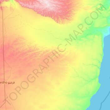
Nom : Carte topographique Bari, altitude, relief.
Lieu : Bari, Iskushuban, Bari, Puntland, Somalia (9.00000 49.00000 11.00000 51.00000)
Altitude moyenne : 503 m
Altitude minimum : -2 m
Altitude maximum : 1 790 m
In terms of landmass, Bari is the largest province in the Federal Republic of Somalia. The highest point in this region is Mount Bahaya, the third tallest mountain in Somalia with an elevation of 2120 meters; other notable peaks include Karkaar and Cal Miskaad mountains.