
Carte topographique The Municipal District of Cahir — Cashel
Carte interactive
Cliquez sur la carte pour afficher l’altitude.
À propos de cette carte
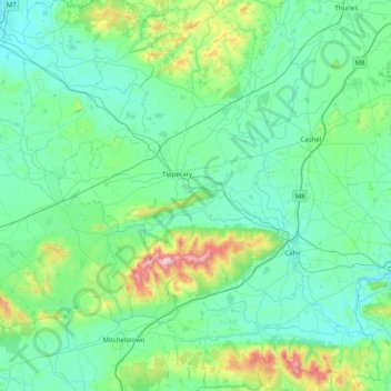
Nom : Carte topographique The Municipal District of Cahir — Cashel, altitude, relief.
Altitude moyenne : 143 m
Altitude minimum : 17 m
Altitude maximum : 904 m
Autres cartes topographiques
Cliquez sur une carte pour visualiser sa topographie, son altitude et son relief.
Pike
Pike, Graigue, The Municipal District of Nenagh, Comté de Tipperary, Munster, Irlande
Altitude moyenne : 50 m
Ardfinnan
Ardfinnan, The Municipal District of Cahir — Cashel, Comté de Tipperary, Munster, E91 A7D8, Irlande
Altitude moyenne : 55 m
Green
Green, Cashel Urban, The Municipal District of Cahir — Cashel, Comté de Tipperary, Munster, E25 RD21, Irlande
Altitude moyenne : 117 m
Redwood
Redwood, The Municipal District of Nenagh, Comté de Tipperary, Munster, E45 VF25, Irlande
Altitude moyenne : 48 m