
Carte topographique Mariakerke
Carte interactive
Cliquez sur la carte pour afficher l’altitude.
À propos de cette carte
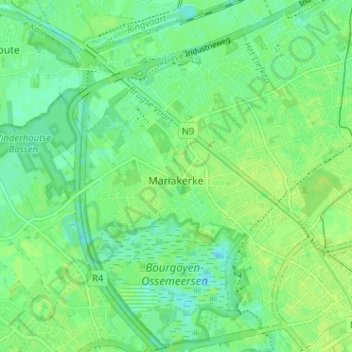
Nom : Carte topographique Mariakerke, altitude, relief.
Lieu : Mariakerke, Gent, Oost-Vlaanderen, 9030, België (51.05318 3.65758 51.09320 3.70671)
Altitude moyenne : 7 m
Altitude minimum : -8 m
Altitude maximum : 11 m
Autres cartes topographiques
Cliquez sur une carte pour visualiser sa topographie, son altitude et son relief.
Zwijnaarde
België > Oost-Vlaanderen > Gent > Gent
Zwijnaarde, Gent, Oost-Vlaanderen, Vlaanderen, 9052, België
Altitude moyenne : 9 m
Sint-Amandsberg
België > Oost-Vlaanderen > Gent > Gent
Sint-Amandsberg, Gent, Oost-Vlaanderen, Vlaanderen, 9040, België
Altitude moyenne : 8 m
Gent
België > Oost-Vlaanderen > Gent > Gent
Gent, Oost-Vlaanderen, Vlaanderen, 24-32, België
Altitude moyenne : 12 m
Drongen
België > Oost-Vlaanderen > Gent > Gent
Drongen, Gent, Oost-Vlaanderen, Vlaanderen, 9031, België
Altitude moyenne : 7 m
Groenzone Scandinaviëstraat
België > Oost-Vlaanderen > Gent > Gent
Groenzone Scandinaviëstraat, Muide, Gent, Oost-Vlaanderen, Vlaanderen, België
Altitude moyenne : 8 m
Westelijke Leie
België > Oost-Vlaanderen > Gent > Gent
Westelijke Leie, Gent, Oost-Vlaanderen, Vlaanderen, 9000, België
Altitude moyenne : 8 m