
Carte topographique Calvert Cliffs
Carte interactive
Cliquez sur la carte pour afficher l’altitude.
À propos de cette carte
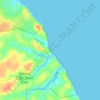
Nom : Carte topographique Calvert Cliffs, altitude, relief.
Altitude moyenne : 11 m
Altitude minimum : 0 m
Altitude maximum : 41 m
Autres cartes topographiques
Cliquez sur une carte pour visualiser sa topographie, son altitude et son relief.
Queensberry
United States > Maryland > Calvert County > Prince Frederick
Queensberry, Prince Frederick, Calvert County, Maryland, 20678, United States
Altitude moyenne : 37 m
Lusby
United States > Maryland > Calvert County
Lusby, Calvert County, Maryland, United States
Altitude moyenne : 26 m
Lusby
United States > Maryland > Calvert County
Lusby, Calvert County, Maryland, 20657, United States
Altitude moyenne : 25 m
Solomons
United States > Maryland > Calvert County
Solomons, Calvert County, Maryland, 20688, United States
Altitude moyenne : 9 m
Ravenshead
United States > Maryland > Calvert County
Ravenshead, Calvert County, Maryland, 20610, United States
Altitude moyenne : 22 m
Mutual Consent
United States > Maryland > Calvert County > Mutual Consent
Mutual Consent, Calvert County, Maryland, 20676, United States
Altitude moyenne : 32 m
Solomons
United States > Maryland > Calvert County > Solomons
Solomons, Calvert County, Maryland, United States
Altitude moyenne : 4 m