
Carte topographique Ota
Carte interactive
Cliquez sur la carte pour afficher l’altitude.
À propos de cette carte
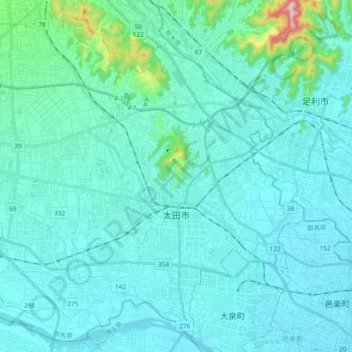
Nom : Carte topographique Ota, altitude, relief.
Lieu : Ota, Gunma Prefecture, Japan (36.23644 139.25576 36.37874 139.44364)
Altitude moyenne : 61 m
Altitude minimum : 21 m
Altitude maximum : 414 m
Ōta is located in the extreme southeastern portion of Gunma Prefecture in the northern Kantō Plains, bordered by Tochigi Prefecture to the east and Saitama Prefecture to the south. The city is located 80 kilometres (50 mi) northwest of Tokyo between the Tone and Watarase rivers. It is located about 80 kilometers northwest of central Tokyo, about 30 kilometers east of the prefectural capital at Maebashi, about 40 kilometers east of Takasaki. The elevation of the city ranges from 30–40 meters in lowland in the south, southwest, northeast, and east, to 40–70 meters in the northwest.
Autres cartes topographiques
Cliquez sur une carte pour visualiser sa topographie, son altitude et son relief.
Mount Fuji
Japan > Sunto County > Oyama
Mount Fuji, Oyama, Sunto County, Shizuoka Prefecture, Chubu Region, Japan
Altitude moyenne : 3 261 m
Ibaraki
Ibaraki, Higashiibaraki County, Ibaraki Prefecture, 311-3116, Japan
Altitude moyenne : 26 m
Maborikaigan 4-chome Park
Maborikaigan 4-chome Park, Maboricho 3-chome, Yokosuka, Kanagawa Prefecture, 238-8550, Japan
Altitude moyenne : 22 m
Lake Sanaru
Lake Sanaru, Hamamatsu, Shizuoka Prefecture, Chubu Region, Japan
Altitude moyenne : 16 m
Motoyama
Motoyama, Nagaoka County, Kochi Prefecture, 781-3601, Japan
Altitude moyenne : 679 m
Setouchi
Setouchi, Oshima County, Kagoshima Prefecture, Japan
Altitude moyenne : 26 m
Higashishirakawa
Higashishirakawa, Kamo County, Gifu Prefecture, Chubu Region, 509-1392, Japan
Altitude moyenne : 658 m
Nishikigaoka-chuo Park
Nishikigaoka-chuo Park, Nishikigaoka 2-chome, Aoba Ward, Sendai, Miyagi Prefecture, Japan
Altitude moyenne : 197 m