
Carte topographique Curraghboy
Carte interactive
Cliquez sur la carte pour afficher l’altitude.
À propos de cette carte
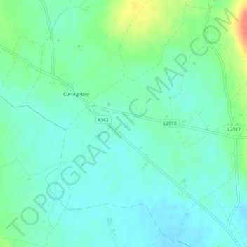
Nom : Carte topographique Curraghboy, altitude, relief.
Altitude moyenne : 69 m
Altitude minimum : 54 m
Altitude maximum : 111 m
Autres cartes topographiques
Cliquez sur une carte pour visualiser sa topographie, son altitude et son relief.
Roscommon Municipal District
Roscommon Municipal District, County Roscommon, Connacht, Ireland
Altitude moyenne : 75 m
Liberty
Liberty, Ballydangan Electoral Division, Athlone Municipal District, County Roscommon, Connacht, Ireland
Altitude moyenne : 51 m
Frenchpark
Ireland > County Roscommon > Frenchpark
Frenchpark, Boyle Municipal District, County Roscommon, Connacht, Ireland
Altitude moyenne : 81 m
Lurgan
Lurgan, Kilcolagh ED, Boyle Municipal District, County Roscommon, Connacht, Ireland
Altitude moyenne : 70 m