
Carte topographique Telluride
Carte interactive
Cliquez sur la carte pour afficher l’altitude.
À propos de cette carte
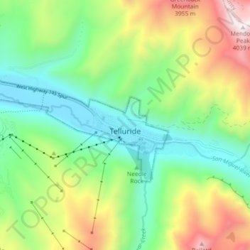
Nom : Carte topographique Telluride, altitude, relief.
Altitude moyenne : 3 125 m
Altitude minimum : 2 647 m
Altitude maximum : 4 023 m
Telluride has an elevation of 8,750 feet (2,670 m) in an isolated spot in Southwest Colorado. From the west, Colorado Route 145 is the most common way into Telluride; two other passes enter the town, Imogene Pass and Black Bear Pass.
Autres cartes topographiques
Cliquez sur une carte pour visualiser sa topographie, son altitude et son relief.
Dunn Peak
United States > Colorado > San Miguel County
Dunn Peak, San Miguel County, Colorado, United States
Altitude moyenne : 3 487 m