
Faire un don
Équipez-vous pour votre prochaine aventure :
En tant que Partenaire Amazon, ce site perçoit une commission sur les achats éligibles sans surcoût pour vous.
Carte topographique Lynn Canyon Park
Cliquez sur la carte pour afficher l’altitude.
Faire un don
Équipez-vous pour votre prochaine aventure :
En tant que Partenaire Amazon, ce site perçoit une commission sur les achats éligibles sans surcoût pour vous.
Lynn Canyon Park
The ecology of Lynn Valley is quite vast as it expands to the entire North Vancouver area. There are several species of animals that can be found both within the Lynn Canyon Park as well as other surrounding regions such as Horseshoe Bay and the local mountains. Just like the wildlife in the area, the plant and vegetation is highly variable as the altitude of the regions change, however the majority of the vegetation in the area is a strong resemblance of Vancouver's temperate rainforest.
Faire un don
Équipez-vous pour votre prochaine aventure :
En tant que Partenaire Amazon, ce site perçoit une commission sur les achats éligibles sans surcoût pour vous.
À propos de cette carte
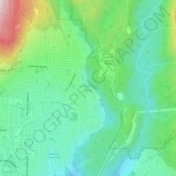
Nom : Carte topographique Lynn Canyon Park, altitude, relief.
Altitude moyenne : 184 m
Altitude minimum : 35 m
Altitude maximum : 562 m
Faire un don
Équipez-vous pour votre prochaine aventure :
En tant que Partenaire Amazon, ce site perçoit une commission sur les achats éligibles sans surcoût pour vous.
Autres cartes topographiques
Cliquez sur une carte pour visualiser sa topographie, son altitude et son relief.
Stanley Park
Canada > British Columbia > Metro Vancouver Regional District > Vancouver
Altitude moyenne : 14 m
Grouse Mountain
Canada > British Columbia > Metro Vancouver Regional District
Grouse Mountain is one of the North Shore Mountains of the Pacific Ranges in the District Municipality of North Vancouver, British Columbia, Canada. With a maximum elevation of over 1,200 m (4,100 feet) at its peak, the mountain is the site of an alpine ski area, Grouse Mountain Resort, which overlooks Greater…
Altitude moyenne : 968 m
Burnaby Mountain
Canada > British Columbia > Metro Vancouver Regional District > Burnaby
Due to its relatively high elevation, snow will often fall on the higher levels of Burnaby Mountain while rain falls in the surrounding cities. Tobogganing is a popular pastime at Centennial Park on winter days with snow.
Altitude moyenne : 167 m
Faire un don
Équipez-vous pour votre prochaine aventure :
En tant que Partenaire Amazon, ce site perçoit une commission sur les achats éligibles sans surcoût pour vous.
Langley Township
Canada > British Columbia > Metro Vancouver Regional District > Township of Langley > Langley Township
Altitude moyenne : 37 m
Burnaby
Canada > British Columbia > Metro Vancouver Regional District > Burnaby
Burnaby occupies 98.60 square kilometres (38.07 sq mi) and is located at the geographic centre of the Metro Vancouver area and home to the Metro Vancouver regional government in Metrotown. Situated between the city of Vancouver on the west and Port Moody, Coquitlam, and New Westminster on the east, Burnaby is…
Altitude moyenne : 144 m
Coquitlam
Canada > British Columbia > Metro Vancouver Regional District > Coquitlam
Southwest Coquitlam comprises the original core of the city, with Maillardville and Fraser River industrial sector giving way to the large residential areas of Austin Heights, colloquially referred to as "The Bump" due to its high and flat plateau topography. These older residences, with larger property…
Altitude moyenne : 230 m
Mount Seymour
Canada > British Columbia > Metro Vancouver Regional District > District of North Vancouver
Altitude moyenne : 1 030 m
Faire un don
Équipez-vous pour votre prochaine aventure :
En tant que Partenaire Amazon, ce site perçoit une commission sur les achats éligibles sans surcoût pour vous.
Little Mountain
Canada > British Columbia > Metro Vancouver Regional District > Vancouver
Little Mountain, elevation 125 m (410 ft), is a mountain in the central part of the city of Vancouver, British Columbia, Canada. The mountain is home to Queen Elizabeth Park, which sits at the top of the mountain, and Nat Bailey Stadium, which is located near the base. The mountain lends its name to the Riley…
Altitude moyenne : 81 m
South Aldergrove Park
Canada > British Columbia > Metro Vancouver Regional District > Township of Langley
Altitude moyenne : 104 m
Cambie Park
Canada > British Columbia > Metro Vancouver Regional District > Vancouver
Altitude moyenne : 61 m
Ioco
Canada > British Columbia > Metro Vancouver Regional District > Port Moody
Altitude moyenne : 97 m
Faire un don
Équipez-vous pour votre prochaine aventure :
En tant que Partenaire Amazon, ce site perçoit une commission sur les achats éligibles sans surcoût pour vous.
Poplar Island
Canada > British Columbia > Metro Vancouver Regional District > New Westminster
Altitude moyenne : 32 m
Mike Lake
Canada > British Columbia > Metro Vancouver Regional District > Maple Ridge
Altitude moyenne : 297 m
Faire un don
Équipez-vous pour votre prochaine aventure :
En tant que Partenaire Amazon, ce site perçoit une commission sur les achats éligibles sans surcoût pour vous.
Crystal Falls
Canada > British Columbia > Metro Vancouver Regional District > Coquitlam
Altitude moyenne : 221 m
Sheffield Park
Canada > British Columbia > Metro Vancouver Regional District > Coquitlam
Altitude moyenne : 153 m
Burke Mountain Pioneer Park
Canada > British Columbia > Metro Vancouver Regional District > Coquitlam
Altitude moyenne : 129 m
Panorama Park Off-Leash Area
Canada > British Columbia > Metro Vancouver Regional District > Surrey
Altitude moyenne : 76 m
Faire un don
Équipez-vous pour votre prochaine aventure :
En tant que Partenaire Amazon, ce site perçoit une commission sur les achats éligibles sans surcoût pour vous.
Stoney Creek Park
Canada > British Columbia > Metro Vancouver Regional District > Burnaby
Altitude moyenne : 85 m
Harvey Creek Debris Flow Control Structure
Canada > British Columbia > Metro Vancouver Regional District > Lions Bay
Altitude moyenne : 322 m
White Pine Beach
Canada > British Columbia > Metro Vancouver Regional District > Port Moody
Altitude moyenne : 125 m
Faire un don
Équipez-vous pour votre prochaine aventure :
En tant que Partenaire Amazon, ce site perçoit une commission sur les achats éligibles sans surcoût pour vous.
Mitchell Island
Canada > British Columbia > Metro Vancouver Regional District > Richmond
Altitude moyenne : 14 m
North Peak
Canada > British Columbia > Metro Vancouver Regional District > Bowen Island Municipality
Altitude moyenne : 331 m
Woodlot 0007
Canada > British Columbia > Metro Vancouver Regional District > Maple Ridge
Altitude moyenne : 322 m
Queen Elizabeth Park
Canada > British Columbia > Metro Vancouver Regional District > Vancouver
Altitude moyenne : 81 m
Faire un don
Équipez-vous pour votre prochaine aventure :
En tant que Partenaire Amazon, ce site perçoit une commission sur les achats éligibles sans surcoût pour vous.
Richmond
Canada > British Columbia > Metro Vancouver Regional District > Richmond
Altitude moyenne : 15 m
Wreck Beach
Canada > British Columbia > Metro Vancouver Regional District > Electoral Area A
Altitude moyenne : 32 m
Faire un don
Équipez-vous pour votre prochaine aventure :
En tant que Partenaire Amazon, ce site perçoit une commission sur les achats éligibles sans surcoût pour vous.
Burnaby Lake Regional Park
Canada > British Columbia > Metro Vancouver Regional District > Burnaby
Altitude moyenne : 51 m
Green Timbers Urban Forest
Canada > British Columbia > Metro Vancouver Regional District > Surrey
Altitude moyenne : 100 m
Black Mountain (North Summit)
Canada > British Columbia > Metro Vancouver Regional District > West Vancouver
Altitude moyenne : 931 m
Barge Park
Canada > British Columbia > Metro Vancouver Regional District > White Rock
Altitude moyenne : 53 m
Faire un don
Équipez-vous pour votre prochaine aventure :
En tant que Partenaire Amazon, ce site perçoit une commission sur les achats éligibles sans surcoût pour vous.
Queen Elizabeth Park
Canada > British Columbia > Metro Vancouver Regional District > Vancouver
Altitude moyenne : 81 m
Cougar Creek Park
Canada > British Columbia > Metro Vancouver Regional District > Surrey
Altitude moyenne : 86 m
Tynehead Regional Park
Canada > British Columbia > Metro Vancouver Regional District > Surrey
Altitude moyenne : 45 m
Faire un don
Équipez-vous pour votre prochaine aventure :
En tant que Partenaire Amazon, ce site perçoit une commission sur les achats éligibles sans surcoût pour vous.
Barnes Lake
Canada > British Columbia > Metro Vancouver Regional District > Electoral Area A
Altitude moyenne : 1 277 m
Essondale Islet
Canada > British Columbia > Metro Vancouver Regional District > Port Coquitlam
Altitude moyenne : 12 m
Annacis Island
Canada > British Columbia > Metro Vancouver Regional District > Delta
Altitude moyenne : 16 m
Queen Elizabeth Park
Canada > British Columbia > Metro Vancouver Regional District > Vancouver
Altitude moyenne : 81 m
Faire un don
Équipez-vous pour votre prochaine aventure :
En tant que Partenaire Amazon, ce site perçoit une commission sur les achats éligibles sans surcoût pour vous.
Burnaby Mountain
Canada > British Columbia > Metro Vancouver Regional District > Burnaby
Due to its relatively high elevation, snow will often fall on the higher levels of Burnaby Mountain while rain falls in the surrounding cities. Tobogganing is a popular pastime at Centennial Park on winter days with snow.
Altitude moyenne : 167 m
Morgan Heights
Canada > British Columbia > Metro Vancouver Regional District > Surrey
Altitude moyenne : 61 m
Kensington Park
Canada > British Columbia > Metro Vancouver Regional District > Vancouver
Altitude moyenne : 81 m
Seymour River
Canada > British Columbia > Metro Vancouver Regional District > Electoral Area A
Altitude moyenne : 490 m
Faire un don
Équipez-vous pour votre prochaine aventure :
En tant que Partenaire Amazon, ce site perçoit une commission sur les achats éligibles sans surcoût pour vous.
Jericho Beach
Canada > British Columbia > Metro Vancouver Regional District > Vancouver
Altitude moyenne : 20 m
Crescent Beach
Canada > British Columbia > Metro Vancouver Regional District > Surrey
Altitude moyenne : 22 m
Westminster Pier Park
Canada > British Columbia > Metro Vancouver Regional District > New Westminster
Altitude moyenne : 27 m
Faire un don
Équipez-vous pour votre prochaine aventure :
En tant que Partenaire Amazon, ce site perçoit une commission sur les achats éligibles sans surcoût pour vous.
Yew Lake
Canada > British Columbia > Metro Vancouver Regional District > West Vancouver
Altitude moyenne : 990 m
Livingstone Lake
Canada > British Columbia > Metro Vancouver Regional District > Vancouver
Altitude moyenne : 86 m
Newton Athletic Park
Canada > British Columbia > Metro Vancouver Regional District > Surrey
Altitude moyenne : 86 m
Ocean Rocks Viewpoint
Canada > British Columbia > Metro Vancouver Regional District > Bowen Island Municipality
Altitude moyenne : 33 m
Faire un don
Équipez-vous pour votre prochaine aventure :
En tant que Partenaire Amazon, ce site perçoit une commission sur les achats éligibles sans surcoût pour vous.
Annacis Island
Canada > British Columbia > Metro Vancouver Regional District > Delta
Altitude moyenne : 16 m
Finn Slough
Canada > British Columbia > Metro Vancouver Regional District > Richmond
Altitude moyenne : 2 m
Town Centre Park
Canada > British Columbia > Metro Vancouver Regional District > Coquitlam
Altitude moyenne : 62 m
Mundy Park
Canada > British Columbia > Metro Vancouver Regional District > Coquitlam
Altitude moyenne : 139 m
Faire un don
Équipez-vous pour votre prochaine aventure :
En tant que Partenaire Amazon, ce site perçoit une commission sur les achats éligibles sans surcoût pour vous.
Trout Lake
Canada > British Columbia > Metro Vancouver Regional District > Vancouver
Altitude moyenne : 52 m
Riverway Sports Complex
Canada > British Columbia > Metro Vancouver Regional District > Burnaby
Altitude moyenne : 42 m
Alouette Lake
Canada > British Columbia > Metro Vancouver Regional District > Maple Ridge
Altitude moyenne : 549 m
Central Park
Canada > British Columbia > Metro Vancouver Regional District > Burnaby
Altitude moyenne : 113 m
Faire un don
Équipez-vous pour votre prochaine aventure :
En tant que Partenaire Amazon, ce site perçoit une commission sur les achats éligibles sans surcoût pour vous.
Mosquito Creek Park
Canada > British Columbia > Metro Vancouver Regional District
Altitude moyenne : 214 m
Walnut Park
Canada > British Columbia > Metro Vancouver Regional District > Surrey
Altitude moyenne : 49 m
English Bay Beach
Canada > British Columbia > Metro Vancouver Regional District > Vancouver
Altitude moyenne : 12 m
Cliff Falls
Canada > British Columbia > Metro Vancouver Regional District > Maple Ridge
Altitude moyenne : 106 m
Faire un don
Équipez-vous pour votre prochaine aventure :
En tant que Partenaire Amazon, ce site perçoit une commission sur les achats éligibles sans surcoût pour vous.
Fraser River (North Arm)
Canada > British Columbia > Metro Vancouver Regional District > Richmond
Altitude moyenne : 27 m
White Rock
Canada > British Columbia > Metro Vancouver Regional District > White Rock > White Rock
Altitude moyenne : 38 m
Andy Livingstone Park
Canada > British Columbia > Metro Vancouver Regional District > Vancouver
Altitude moyenne : 12 m
Mount Eldee
Canada > British Columbia > Metro Vancouver Regional District > Electoral Area A
Altitude moyenne : 1 026 m
Faire un don
Équipez-vous pour votre prochaine aventure :
En tant que Partenaire Amazon, ce site perçoit une commission sur les achats éligibles sans surcoût pour vous.
Blue Mountain Park
Canada > British Columbia > Metro Vancouver Regional District > Coquitlam
Altitude moyenne : 119 m
Strathcona Park
Canada > British Columbia > Metro Vancouver Regional District > Vancouver
Altitude moyenne : 17 m
Stanley Park
Canada > British Columbia > Metro Vancouver Regional District > Vancouver
Altitude moyenne : 14 m
Westburnco Dog Park
Canada > British Columbia > Metro Vancouver Regional District > New Westminster
Altitude moyenne : 68 m
Faire un don
Équipez-vous pour votre prochaine aventure :
En tant que Partenaire Amazon, ce site perçoit une commission sur les achats éligibles sans surcoût pour vous.
Whonnock Lake
Canada > British Columbia > Metro Vancouver Regional District > Maple Ridge
Altitude moyenne : 190 m
Passage Island
Canada > British Columbia > Metro Vancouver Regional District > Electoral Area A
Altitude moyenne : 0 m
Tynehead Regional Park
Canada > British Columbia > Metro Vancouver Regional District > Surrey
Altitude moyenne : 45 m
Faire un don
Équipez-vous pour votre prochaine aventure :
En tant que Partenaire Amazon, ce site perçoit une commission sur les achats éligibles sans surcoût pour vous.
Port Coquitlam
Canada > British Columbia > Metro Vancouver Regional District > Port Coquitlam
Altitude moyenne : 185 m
Ketcheson Neighbourhood Park
Canada > British Columbia > Metro Vancouver Regional District > Richmond
Altitude moyenne : 3 m
Fraser River Park
Canada > British Columbia > Metro Vancouver Regional District > Vancouver
Altitude moyenne : 19 m
Langley City
Canada > British Columbia > Metro Vancouver Regional District > Langley City
Altitude moyenne : 57 m
Faire un don
Équipez-vous pour votre prochaine aventure :
En tant que Partenaire Amazon, ce site perçoit une commission sur les achats éligibles sans surcoût pour vous.
Still Creek
Canada > British Columbia > Metro Vancouver Regional District > Vancouver
Altitude moyenne : 65 m
Pitt Meadows
Canada > British Columbia > Metro Vancouver Regional District > Pitt Meadows > Pitt Meadows
Altitude moyenne : 7 m
Mount Seymour
Canada > British Columbia > Metro Vancouver Regional District > District of North Vancouver
Altitude moyenne : 1 030 m
Faire un don
Équipez-vous pour votre prochaine aventure :
En tant que Partenaire Amazon, ce site perçoit une commission sur les achats éligibles sans surcoût pour vous.
Port Moody
Canada > British Columbia > Metro Vancouver Regional District > Port Moody
Altitude moyenne : 233 m
Charleson Park
Canada > British Columbia > Metro Vancouver Regional District > Vancouver
Altitude moyenne : 28 m
Gaston Park
Canada > British Columbia > Metro Vancouver Regional District > Vancouver
Altitude moyenne : 104 m
Brewers Park
Canada > British Columbia > Metro Vancouver Regional District > Vancouver
Altitude moyenne : 64 m
Faire un don
Équipez-vous pour votre prochaine aventure :
En tant que Partenaire Amazon, ce site perçoit une commission sur les achats éligibles sans surcoût pour vous.
Point Grey Park Site at Trutch Street
Canada > British Columbia > Metro Vancouver Regional District > Vancouver
Altitude moyenne : 15 m
Aldergrove Regional Park
Canada > British Columbia > Metro Vancouver Regional District > Township of Langley
Altitude moyenne : 64 m
Barnston Island
Canada > British Columbia > Metro Vancouver Regional District > Electoral Area A
Altitude moyenne : 6 m
Maple Ridge Park
Canada > British Columbia > Metro Vancouver Regional District > Maple Ridge
Altitude moyenne : 41 m
Faire un don
Équipez-vous pour votre prochaine aventure :
En tant que Partenaire Amazon, ce site perçoit une commission sur les achats éligibles sans surcoût pour vous.
Barnet Marine Park
Canada > British Columbia > Metro Vancouver Regional District > Burnaby
Altitude moyenne : 95 m
Slocan Park
Canada > British Columbia > Metro Vancouver Regional District > Vancouver
Altitude moyenne : 81 m
Waterfront Park
Canada > British Columbia > Metro Vancouver Regional District > North Vancouver
Altitude moyenne : 22 m
Cottonwood Park
Canada > British Columbia > Metro Vancouver Regional District > Surrey
Altitude moyenne : 37 m
Faire un don
Équipez-vous pour votre prochaine aventure :
En tant que Partenaire Amazon, ce site perçoit une commission sur les achats éligibles sans surcoût pour vous.