
Carte topographique Brussels–Scheldt Maritime Canal
Carte interactive
Cliquez sur la carte pour afficher l’altitude.
À propos de cette carte
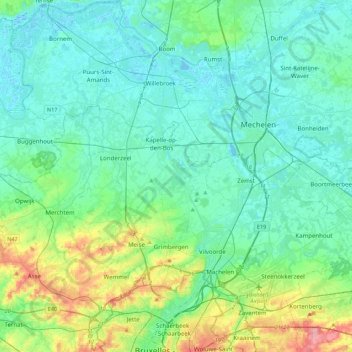
Nom : Carte topographique Brussels–Scheldt Maritime Canal, altitude, relief.
Altitude moyenne : 22 m
Altitude minimum : -3 m
Altitude maximum : 110 m
The difference in altitude of 14 m between Brussels and the Rupel river at Willebroek was achieved with 4 locks. With the commissioning of the canal, the ships could now avoid navigating the Zenne and being subject to tax in Mechelen.
Autres cartes topographiques
Cliquez sur une carte pour visualiser sa topographie, son altitude et son relief.
Woluwe
Belgium > Flemish Brabant > Brussels-Capital > Brussels
Woluwe, Brussels, City of Brussels, Brussels-Capital, Flemish Brabant, Brussels-Capital, 1831, Belgium
Altitude moyenne : 64 m