
Carte topographique Eisenerz
Carte interactive
Cliquez sur la carte pour afficher l’altitude.
Eisenerz
A few miles northwest of Eisenerz stands Leopoldstein Castle, and near it Leopoldstein Lake. This lake, with its dark green water at an elevation of 2,028 feet (618 m), and surrounded on all sides by high peaks, is not large and has a depth of 100 ft (30 m).
À propos de cette carte
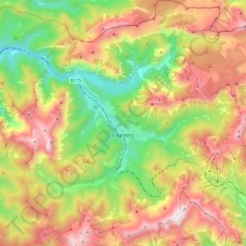
Nom : Carte topographique Eisenerz, altitude, relief.
Lieu : Eisenerz, Bezirk Leoben, Styria, 8790, Austria (47.48237 14.80499 47.61450 14.98340)
Altitude moyenne : 1 283 m
Altitude minimum : 555 m
Altitude maximum : 2 139 m
Autres cartes topographiques
Cliquez sur une carte pour visualiser sa topographie, son altitude et son relief.