
Faire un don
Équipez-vous pour votre prochaine aventure :
En tant que Partenaire Amazon, ce site perçoit une commission sur les achats éligibles sans surcoût pour vous.
Carte topographique Hillary Step
Cliquez sur la carte pour afficher l’altitude.
Faire un don
Équipez-vous pour votre prochaine aventure :
En tant que Partenaire Amazon, ce site perçoit une commission sur les achats éligibles sans surcoût pour vous.
Hillary Step
The step was named after Sir Edmund Hillary, who was the first known person, along with Tenzing Norgay, to scale it on the way to the summit during the 1953 British Mount Everest Expedition. Hillary and Tenzing first climbed the Hillary Step on 29 May 1953 by climbing the crack between the snow and the rock. Hillary reported that the snow on the step was harder than at lower elevation. Hillary wrote in 1953.
Faire un don
Équipez-vous pour votre prochaine aventure :
En tant que Partenaire Amazon, ce site perçoit une commission sur les achats éligibles sans surcoût pour vous.
À propos de cette carte
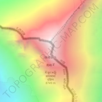
Nom : Carte topographique Hillary Step, altitude, relief.
Altitude moyenne : 7 824 m
Altitude minimum : 6 597 m
Altitude maximum : 8 849 m
Faire un don
Équipez-vous pour votre prochaine aventure :
En tant que Partenaire Amazon, ce site perçoit une commission sur les achats éligibles sans surcoût pour vous.
Autres cartes topographiques
Cliquez sur une carte pour visualiser sa topographie, son altitude et son relief.