
Carte topographique Kingman
Carte interactive
Cliquez sur la carte pour afficher l’altitude.
À propos de cette carte
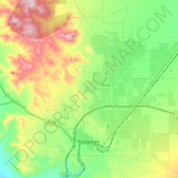
Nom : Carte topographique Kingman, altitude, relief.
Lieu : Kingman, Mohave County, Arizona, United States (35.17405 -114.09481 35.28733 -113.92299)
Altitude moyenne : 1 131 m
Altitude minimum : 827 m
Altitude maximum : 1 648 m
Lt. Edward Fitzgerald Beale, a U.S. Navy officer in the service of the Army Corps of Topographical Engineers, was ordered by the U.S. War Department to build a federal wagon road across the 35th parallel. His secondary orders were to test the feasibility of the use of camels as pack animals in the Southwestern desert. Beale traveled through the present-day Kingman in 1857 surveying the road and in 1859 to build the road. Beale's Wagon Road became part of U.S. Route 66 and later Interstate 40. Remnants of the wagon road can still be seen in White Cliffs Canyon in Kingman.
Autres cartes topographiques
Cliquez sur une carte pour visualiser sa topographie, son altitude et son relief.
Centennial Park
United States > Arizona > Mohave County
Centennial Park, Mohave County, Arizona, 86021, United States
Altitude moyenne : 1 504 m
Topock
United States > Arizona > Mohave County > Topock
Topock, Mohave County, Arizona, United States
Altitude moyenne : 180 m
Bullhead City
United States > Arizona > Mohave County > Bullhead City
Bullhead City, Mohave County, Arizona, 89029, United States
Altitude moyenne : 571 m
Lake Havasu City
United States > Arizona > Mohave County
Lake Havasu City, Mohave County, Arizona, United States
Altitude moyenne : 279 m