
Faire un don
Équipez-vous pour votre prochaine aventure :
En tant que Partenaire Amazon, ce site perçoit une commission sur les achats éligibles sans surcoût pour vous.
Carte topographique Kawagarbo
Cliquez sur la carte pour afficher l’altitude.
Faire un don
Équipez-vous pour votre prochaine aventure :
En tant que Partenaire Amazon, ce site perçoit une commission sur les achats éligibles sans surcoût pour vous.
Kawagarbo
The Meili Xue Shan has over 20 peaks with permanent snow cover, including six peaks over 6,000 m (19,700 ft). Topographic extremes are immense, with vertical relief ranging from less than 2,000 m along the Mekong River on the east to 6,740 m on the summit of Kawagarpo within 10 km horizontal distance. Even greater topographic relief is found on the west or Salween River side of the range. Coincident with this extreme topographic gradient is a similarly steep environmental gradient. Compressed within this short distance are subtropical scrub ecosystems along the arid canyon bottoms, rising through dry oak forests, humid mixed deciduous-coniferous forests, cold temperate coniferous forests, alpine meadows and scree above treeline, to permanent snow on the high peaks. The Mingyong Glacier, descending from the summit of Kawagarbo, terminates at a low elevation just before the subtropical life zone. The range is highly affected by the monsoon, leading to especially unstable snow conditions, which have affected climbing attempts (see below).
Faire un don
Équipez-vous pour votre prochaine aventure :
En tant que Partenaire Amazon, ce site perçoit une commission sur les achats éligibles sans surcoût pour vous.
À propos de cette carte
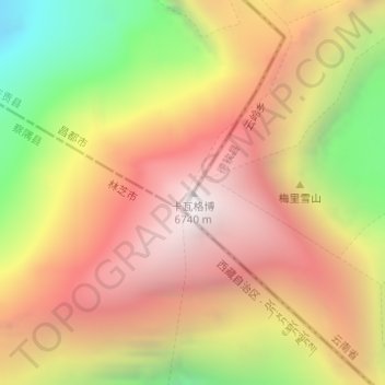
Nom : Carte topographique Kawagarbo, altitude, relief.
Lieu : Kawagarbo, Chamdo City, Tibet, China (28.43966 98.68435 28.43976 98.68445)
Altitude moyenne : 5 809 m
Altitude minimum : 4 620 m
Altitude maximum : 6 698 m
Faire un don
Équipez-vous pour votre prochaine aventure :
En tant que Partenaire Amazon, ce site perçoit une commission sur les achats éligibles sans surcoût pour vous.