
Carte topographique Humphrey
Carte interactive
Cliquez sur la carte pour afficher l’altitude.
À propos de cette carte
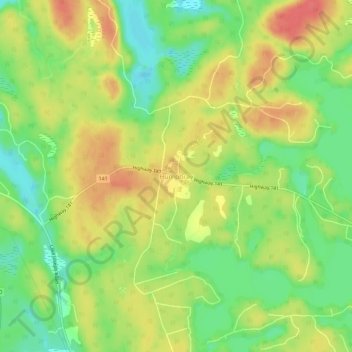
Nom : Carte topographique Humphrey, altitude, relief.
Altitude moyenne : 255 m
Altitude minimum : 225 m
Altitude maximum : 284 m
Autres cartes topographiques
Cliquez sur une carte pour visualiser sa topographie, son altitude et son relief.
Otter Lake
Canada > Ontario > Parry Sound District > Seguin Township
Otter Lake, Seguin Township, Parry Sound District, Central Ontario, Ontario, Canada
Altitude moyenne : 227 m
Salmon Lake
Canada > Ontario > Parry Sound District > Seguin Township
Salmon Lake, Seguin Township, Parry Sound District, Central Ontario, Ontario, Canada
Altitude moyenne : 220 m
Orrville
Canada > Ontario > Parry Sound District > Seguin Township > Orrville
Orrville, Seguin Township, Parry Sound District, Central Ontario, Ontario, Canada
Altitude moyenne : 262 m
Hoben Lake
Canada > Ontario > Parry Sound District > Seguin Township
Hoben Lake, Seguin Township, Parry Sound District, Central Ontario, Ontario, Canada
Altitude moyenne : 249 m
Seeley Bay
Canada > Ontario > Parry Sound District > Seguin Township
Seeley Bay, Seguin Township, Parry Sound District, Central Ontario, Ontario, Canada
Altitude moyenne : 238 m
Clear Lake
Canada > Ontario > Parry Sound District > Seguin Township
Clear Lake, Seguin Township, Parry Sound District, Central Ontario, Ontario, Canada
Altitude moyenne : 252 m
Rosseau
Canada > Ontario > Parry Sound District > Seguin Township
Rosseau, Seguin Township, Parry Sound District, Central Ontario, Ontario, P0C 1J0, Canada
Altitude moyenne : 257 m