
Carte topographique Arshan
Carte interactive
Cliquez sur la carte pour afficher l’altitude.
Arshan
Arshan is located at an altitude of 900 m in a valley at the foot of the snow-capped Sayan Range and the Tunkin Pinnacles. It is 120 km from the Kultuk railway station, 479 km from Ulan-Ude, and 210 km from Irkutsk. Arshan is built on the banks of the Kyngyrga River of the Eastern Sayan Range, which has more than 12 waterfalls. The village is the center of the Arshan rural municipal district.
À propos de cette carte
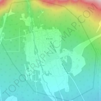
Nom : Carte topographique Arshan, altitude, relief.
Altitude moyenne : 880 m
Altitude minimum : 776 m
Altitude maximum : 1 166 m