
Carte topographique Wind
Carte interactive
Cliquez sur la carte pour afficher l’altitude.
À propos de cette carte
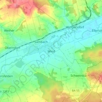
Nom : Carte topographique Wind, altitude, relief.
Altitude moyenne : 284 m
Altitude minimum : 257 m
Altitude maximum : 333 m
Autres cartes topographiques
Cliquez sur une carte pour visualiser sa topographie, son altitude et son relief.
Hallstadt
Deutschland > Bayern > Landkreis Bamberg
Hallstadt, Landkreis Bamberg, Bayern, 96103, Deutschland
Altitude moyenne : 255 m
Litzendorf
Deutschland > Bayern > Landkreis Bamberg > Litzendorf
Litzendorf, Landkreis Bamberg, Bayern, 96123, Deutschland
Altitude moyenne : 362 m