
Carte topographique Bruceton Mills
Carte interactive
Cliquez sur la carte pour afficher l’altitude.
À propos de cette carte
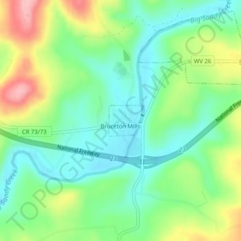
Nom : Carte topographique Bruceton Mills, altitude, relief.
Lieu : Bruceton Mills, Preston County, West Virginia, United States (39.65756 -79.64287 39.66102 -79.63798)
Altitude moyenne : 508 m
Altitude minimum : 458 m
Altitude maximum : 601 m
Autres cartes topographiques
Cliquez sur une carte pour visualiser sa topographie, son altitude et son relief.
Mountain Dale
United States > West Virginia > Preston County
Mountain Dale, Preston County, West Virginia, United States
Altitude moyenne : 734 m
Gladesville
United States > West Virginia > Preston County
Gladesville, Preston County, West Virginia, 26734, United States
Altitude moyenne : 549 m
Victoria
United States > West Virginia > Preston County
Victoria, Preston County, West Virginia, 26374, United States
Altitude moyenne : 474 m
Newburg
United States > West Virginia > Preston County
Newburg, Preston County, West Virginia, United States
Altitude moyenne : 451 m
Preston
United States > West Virginia > Preston County > Preston
Preston, Preston County, West Virginia, 26537, United States
Altitude moyenne : 502 m
Kingwood
United States > West Virginia > Preston County
Kingwood, Preston County, West Virginia, 26537, United States
Altitude moyenne : 530 m