
Carte topographique Myślenice
Carte interactive
Cliquez sur la carte pour afficher l’altitude.
À propos de cette carte
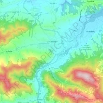
Nom : Carte topographique Myślenice, altitude, relief.
Altitude moyenne : 384 m
Altitude minimum : 267 m
Altitude maximum : 673 m
Autres cartes topographiques
Cliquez sur une carte pour visualiser sa topographie, son altitude et son relief.
Harbutowice
Poland > Lesser Poland Voivodeship > Myślenice County
Harbutowice, gmina Sułkowice, Myślenice County, Lesser Poland Voivodeship, Poland
Altitude moyenne : 483 m
Pcim
Poland > Lesser Poland Voivodeship > Myślenice County
Pcim, gmina Pcim, Myślenice County, Lesser Poland Voivodeship, 32-432, Poland
Altitude moyenne : 483 m
Tenczyn
Poland > Lesser Poland Voivodeship > Myślenice County
Tenczyn, gmina Lubień, Myślenice County, Lesser Poland Voivodeship, Poland
Altitude moyenne : 620 m
Myślenice
Poland > Lesser Poland Voivodeship > Myślenice County > Myślenice > Myślenice
Myślenice, gmina Myślenice, Myślenice County, Lesser Poland Voivodeship, 32-400, Poland
Altitude moyenne : 374 m