
Carte topographique Illmensee
Carte interactive
Cliquez sur la carte pour afficher l’altitude.
À propos de cette carte
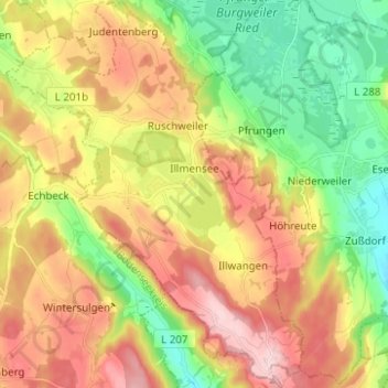
Nom : Carte topographique Illmensee, altitude, relief.
Altitude moyenne : 698 m
Altitude minimum : 577 m
Altitude maximum : 839 m
The municipality (Gemeinde) of Illmensee is situated at the southeastern corner of the district of Sigmaringen, in the German state of Baden-Württemberg. Illmensee lies along Sigmaringen's border with the district of Ravensburg to the east and the Bodensee district to the south. The municipality is physically located in a depression formed by the Würm glaciation in the Upper Swabian hill country [de]. The municipality's three lakes, the Illmensee itself, Ruschweiler [de], and the Volzer [de] lakes, are glacial lakes that were also formed by the Würm glaciation. Elevation above sea level in the municipal area ranges from a high of 833 meters (2,733 ft) Normalnull (NN) to a low of 667 meters (2,188 ft) NN.
Autres cartes topographiques
Cliquez sur une carte pour visualiser sa topographie, son altitude et son relief.
Schnerkingen
Germany > Baden-Württemberg > Landkreis Sigmaringen > Meßkirch
Schnerkingen, Meßkirch, Verwaltungsgemeinschaft Meßkirch, Landkreis Sigmaringen, Baden-Württemberg, 88605, Germany
Altitude moyenne : 634 m
Sigmaringen
Germany > Baden-Württemberg > Landkreis Sigmaringen
Sigmaringen, Gemeindeverwaltungsverband Sigmaringen, Landkreis Sigmaringen, Baden-Württemberg, 72488, Germany
Altitude moyenne : 655 m
Pfullendorf
Germany > Baden-Württemberg > Landkreis Sigmaringen
Pfullendorf, Verwaltungsgemeinschaft Pfullendorf, Landkreis Sigmaringen, Baden-Württemberg, 88630, Germany
Altitude moyenne : 654 m