
Carte topographique Canduman
Carte interactive
Cliquez sur la carte pour afficher l’altitude.
Canduman
It is one of the two (the other one being the municipality of Consolacion) local government units located within the mainland Metro Cebu where the elevation of land is less than 100 m (330 ft).
À propos de cette carte
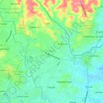
Nom : Carte topographique Canduman, altitude, relief.
Lieu : Canduman, Mandaue, Central Visayas, 6001, Philippines (10.34866 123.91398 10.38866 123.95398)
Altitude moyenne : 37 m
Altitude minimum : 1 m
Altitude maximum : 109 m