
Carte topographique Trosa kommun
Carte interactive
Cliquez sur la carte pour afficher l’altitude.
À propos de cette carte
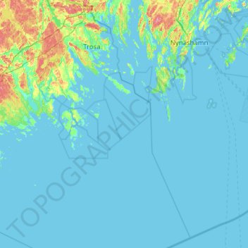
Nom : Carte topographique Trosa kommun, altitude, relief.
Lieu : Trosa kommun, Comté de Södermanland, Suède (58.46785 17.35600 58.99500 17.95441)
Altitude moyenne : 10 m
Altitude minimum : -1 m
Altitude maximum : 81 m
Autres cartes topographiques
Cliquez sur une carte pour visualiser sa topographie, son altitude et son relief.
Eskilstuna kommun
Eskilstuna kommun, Comté de Södermanland, Suède
Altitude moyenne : 34 m
Katrineholms kommun
Katrineholms kommun, Comté de Södermanland, Suède
Altitude moyenne : 52 m
Nyköping
Nyköping, Nyköpings kommun, Comté de Södermanland, 611 33, Suède
Altitude moyenne : 19 m