
Carte topographique Corvallis
Carte interactive
Cliquez sur la carte pour afficher l’altitude.
À propos de cette carte
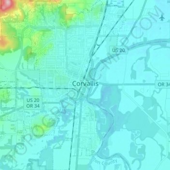
Nom : Carte topographique Corvallis, altitude, relief.
Lieu : Corvallis, Benton County, Oregon, United States (44.51993 -123.33622 44.60724 -123.23104)
Altitude moyenne : 81 m
Altitude minimum : 57 m
Altitude maximum : 324 m
Corvallis is at an elevation of 235 feet (72 m) above sea level. Situated midway in the Willamette Valley, in terms of driving distances, Corvallis is about 46 miles (74 km) east of Newport and the Oregon Coast, 85 miles (137 km) south of Portland, 30 miles (48 km) south of the state capital, Salem, 10 miles (16 km) southwest of Albany, about 10 miles (16 km) west of Interstate 5 at its closest point, and 48 miles (77 km) north of Eugene/Springfield. Oregon Route 99W, a secondary north–south route, also runs through Corvallis. U.S. Route 20 (which leads to Newport) and Oregon Route 34 (which leads to Waldport about 56 miles (90 km) to the west) both secondary East-West routes run through Corvallis from the Oregon Coast. Corvallis is at river mile 131–32 of the Willamette River. Corvallis is bordered on the northwest by the foothills of the Oregon Coast Range, with Bald Hill providing a view of the town.
Autres cartes topographiques
Cliquez sur une carte pour visualiser sa topographie, son altitude et son relief.
Alsea
United States > Oregon > Benton County
Alsea, Benton County, Oregon, 97324, United States
Altitude moyenne : 154 m
Flynn
United States > Oregon > Benton County
Flynn, Benton County, Oregon, 97370, United States
Altitude moyenne : 124 m