Géolocaliser

Carte topographique Montes Subiedes

Carte interactive

Cliquez sur la carte pour afficher l’altitude.

À propos de cette carte

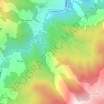
Nom : Carte topographique Montes Subiedes, altitude, relief.

Lieu : Montes Subiedes, Camaleño, Liébana, Cantabria, 39582, España (43.12243 -4.71877 43.14243 -4.69877)

Altitude moyenne : 857 m

Altitude minimum : 459 m

Altitude maximum : 1 415 m

Autres cartes topographiques

Cliquez sur une carte pour visualiser sa topographie, son altitude et son relief.

Vallejo

España > Cantabria > Camaleño

Vallejo, Camaleño, Cantabria, 39587, España

Altitude moyenne : 914 m

Fuente Dé

España > Cantabria > Camaleño

Fuente Dé, Camaleño, Cantabria, 39588, España

Altitude moyenne : 1 505 m

Pico del Buey

España > Cantabria > Camaleño

Pico del Buey, Camaleño, Liébana, Cantabria, 39588, España

Altitude moyenne : 1 462 m

Tanarrio

España > Cantabria > Camaleño

Tanarrio, Camaleño, Cantabria, 39587, España

Altitude moyenne : 810 m