
Carte topographique Tresta
Carte interactive
Cliquez sur la carte pour afficher l’altitude.
À propos de cette carte
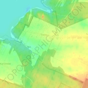
Nom : Carte topographique Tresta, altitude, relief.
Altitude moyenne : 177 m
Altitude minimum : 156 m
Altitude maximum : 198 m
Autres cartes topographiques
Cliquez sur une carte pour visualiser sa topographie, son altitude et son relief.
Ujazd
Poland > Łódź Voivodeship > Tomaszów Mazowiecki County > Ujazd
Ujazd, gmina Ujazd, Tomaszów Mazowiecki County, Łódź Voivodeship, 97-225, Poland
Altitude moyenne : 184 m