
Faire un don
Équipez-vous pour votre prochaine aventure :
En tant que Partenaire Amazon, ce site perçoit une commission sur les achats éligibles sans surcoût pour vous.
Carte topographique Kilsyth
Cliquez sur la carte pour afficher l’altitude.
Faire un don
Équipez-vous pour votre prochaine aventure :
En tant que Partenaire Amazon, ce site perçoit une commission sur les achats éligibles sans surcoût pour vous.
Kilsyth
Historically part of Stirlingshire, Kilsyth is at an elevation of 200 feet (60 metres) above sea level and occupies a narrow strip of land between the Kilsyth Hills to the north and the River Kelvin to the south. To the east and west it is bordered by marshland and bogs. The centre of the town is close to the confluence of the Garrell and Ebroch burns.
Faire un don
Équipez-vous pour votre prochaine aventure :
En tant que Partenaire Amazon, ce site perçoit une commission sur les achats éligibles sans surcoût pour vous.
À propos de cette carte
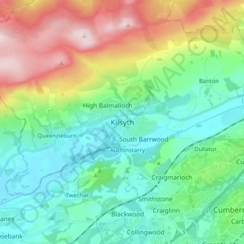
Nom : Carte topographique Kilsyth, altitude, relief.
Lieu : Kilsyth, North Lanarkshire, Scotland, G65 0AQ, United Kingdom (55.93654 -4.09597 56.01654 -4.01597)
Altitude moyenne : 161 m
Altitude minimum : 34 m
Altitude maximum : 462 m
Faire un don
Équipez-vous pour votre prochaine aventure :
En tant que Partenaire Amazon, ce site perçoit une commission sur les achats éligibles sans surcoût pour vous.
Autres cartes topographiques
Cliquez sur une carte pour visualiser sa topographie, son altitude et son relief.
Cumbernauld
United Kingdom > Scotland > North Lanarkshire
Cumbernauld's name probably comes from the Gaelic comar nan allt, meaning "meeting of the burns or streams". There are differing views as to the etymology of this. One theory is that from its high point in the Central Belt, its streams flow both west to the River Clyde and east to the Firth of Forth so…
Altitude moyenne : 113 m
Faire un don
Équipez-vous pour votre prochaine aventure :
En tant que Partenaire Amazon, ce site perçoit une commission sur les achats éligibles sans surcoût pour vous.
Forrestburn Reservoir
United Kingdom > Scotland > North Lanarkshire > Bentfoot
Altitude moyenne : 231 m
Cumbernauld
United Kingdom > Scotland > North Lanarkshire
Cumbernauld's name probably comes from the Gaelic comar nan allt, meaning "meeting of the burns or streams". There are differing views as to the etymology of this. One theory is that from its high point in the Central Belt, its streams flow both west to the River Clyde and east to the Firth of Forth so…
Altitude moyenne : 113 m