
Faire un don
Équipez-vous pour votre prochaine aventure :
En tant que Partenaire Amazon, ce site perçoit une commission sur les achats éligibles sans surcoût pour vous.
Carte topographique Lindbergh
Cliquez sur la carte pour afficher l’altitude.
Faire un don
Équipez-vous pour votre prochaine aventure :
En tant que Partenaire Amazon, ce site perçoit une commission sur les achats éligibles sans surcoût pour vous.
À propos de cette carte
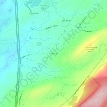
Nom : Carte topographique Lindbergh, altitude, relief.
Altitude moyenne : 386 m
Altitude minimum : 312 m
Altitude maximum : 566 m
Faire un don
Équipez-vous pour votre prochaine aventure :
En tant que Partenaire Amazon, ce site perçoit une commission sur les achats éligibles sans surcoût pour vous.
Autres cartes topographiques
Cliquez sur une carte pour visualiser sa topographie, son altitude et son relief.
Mountain Top
United States > Pennsylvania > Luzerne County > Wright Township
The elevation within the Mountain Top CDP ranges from 1,070 feet (330 m) above sea level along Big Wapwallopen Creek in the southwest, to 1,860 feet (570 m) atop Nescopeck Mountain southwest of Rita, to 1,871 feet (570 m) at the east end of Penobscot Mountain in the north of the CDP. The central village of…
Altitude moyenne : 463 m