
Faire un don
Équipez-vous pour votre prochaine aventure :
En tant que Partenaire Amazon, ce site perçoit une commission sur les achats éligibles sans surcoût pour vous.
Carte topographique Kleinglattbach
Cliquez sur la carte pour afficher l’altitude.
Faire un don
Équipez-vous pour votre prochaine aventure :
En tant que Partenaire Amazon, ce site perçoit une commission sur les achats éligibles sans surcoût pour vous.
Kleinglattbach
Kleinglattbach liegt gut zwei Kilometer nordöstlich der Kernstadt von Vaihingen an der Enz auf etwa 250 m Höhe am Glattbach. Benachbarte Ortschaften sind (von Nordwesten im Uhrzeigersinn) Ensingen, Horrheim, Sersheim, Vaihingen an der Enz und Illingen.
Faire un don
Équipez-vous pour votre prochaine aventure :
En tant que Partenaire Amazon, ce site perçoit une commission sur les achats éligibles sans surcoût pour vous.
À propos de cette carte
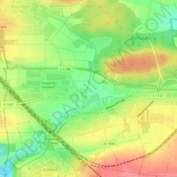
Nom : Carte topographique Kleinglattbach, altitude, relief.
Altitude moyenne : 253 m
Altitude minimum : 212 m
Altitude maximum : 292 m
Faire un don
Équipez-vous pour votre prochaine aventure :
En tant que Partenaire Amazon, ce site perçoit une commission sur les achats éligibles sans surcoût pour vous.