
Carte topographique Shannon
Carte interactive
Cliquez sur la carte pour afficher l’altitude.
À propos de cette carte
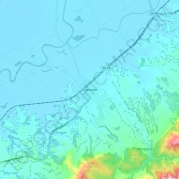
Nom : Carte topographique Shannon, altitude, relief.
Altitude moyenne : 45 m
Altitude minimum : 1 m
Altitude maximum : 467 m
Autres cartes topographiques
Cliquez sur une carte pour visualiser sa topographie, son altitude et son relief.
Moutoa
New Zealand > Shannon > Moutoa
Moutoa, Shannon, Horowhenua District, Manawatu-Whanganui, 4821, New Zealand
Altitude moyenne : 6 m