Carte topographique Strasbourg
Carte interactive
Cliquez sur la carte pour afficher l’altitude.
À propos de cette carte
![Carte topographique Strasbourg, altitude, relief](/pub/maps/relation/7gt6/l45b3/thumbnail.jpg)
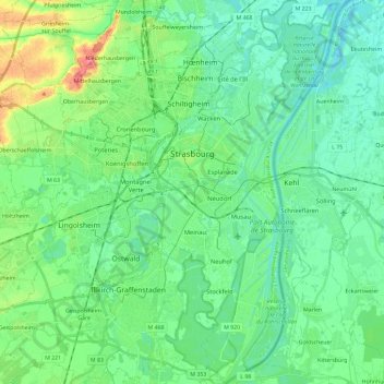
Nom : Carte topographique Strasbourg, altitude, relief.
Lieu : Strasbourg, Bas-Rhin, Grand Est, France métropolitaine, France (48.49186 7.68814 48.64619 7.83606)
Altitude moyenne : 144 m
Altitude minimum : 127 m
Altitude maximum : 193 m
Située à une altitude moyenne de 140 mètres au-dessus du niveau de la mer, Strasbourg est caractérisée par un relief relativement plat. Ainsi au centre-ville, on ne perçoit que de très légères ondulations du terrain, culminant notamment à proximité de la cathédrale et à la croisée de la Grand'Rue et de la rue du Fossé-des-Tanneurs, correspondant aux zones d'habitation les plus anciennes, établies à l'origine sur une butte émergeant des marais environnants. Pour des raisons historiques, le niveau normal d'Amsterdam, ou Normalnull, a pu servir de référent altimétrique, comme en témoignent de vieilles plaques encore visibles. Mais à l'instar du reste de la France métropolitaine, le nivellement général de la France s'applique, et les altitudes sont données par rapport au niveau du marégraphe de Marseille.
Autres cartes topographiques
Cliquez sur une carte pour visualiser sa topographie, son altitude et son relief.
![Carte topographique Reichstett, altitude, relief](/pub/maps/relation/wls8/rg3cz/icon.jpg)
Reichstett
Reichstett, Strasbourg, Bas-Rhin, Grand Est, France métropolitaine, 67116, France
Altitude moyenne : 138 m
![Carte topographique Dinsheim-sur-Bruche, altitude, relief](/pub/maps/relation/3d14/nk951/icon.jpg)
Dinsheim-sur-Bruche
Dinsheim-sur-Bruche, Molsheim, Bas-Rhin, Grand Est, France métropolitaine, 67190, France
Altitude moyenne : 244 m
![Carte topographique Bassemberg, altitude, relief](/pub/maps/relation/k918/641rr/icon.jpg)
Bassemberg
Bassemberg, Sélestat-Erstein, Bas-Rhin, Grand Est, France métropolitaine, 67220, France
Altitude moyenne : 361 m
![Carte topographique Neuviller-la-Roche, altitude, relief](/pub/maps/relation/cp3q/m69k14/icon.jpg)
Neuviller-la-Roche
Neuviller-la-Roche, Molsheim, Bas-Rhin, Grand Est, France métropolitaine, 67130, France
Altitude moyenne : 711 m
![Carte topographique 67370, altitude, relief](/pub/maps/relation/v4s/2fckt6/icon.jpg)
67370
France > Grand Est > Bas-Rhin > Schnersheim
67370, Kleinfrankenheim, Schnersheim, Saverne, Bas-Rhin, Grand Est, France métropolitaine, France
Altitude moyenne : 178 m
![Carte topographique Kuttolsheim, altitude, relief](/pub/maps/relation/kqkl/bk914/icon.jpg)
Kuttolsheim
Kuttolsheim, Saverne, Bas-Rhin, Grand Est, France métropolitaine, 67520, France
Altitude moyenne : 232 m
![Carte topographique Fegersheim, altitude, relief](/pub/maps/relation/82dn/667kl/icon.jpg)
Fegersheim
Fegersheim, Strasbourg, Bas-Rhin, Grand Est, France métropolitaine, 67640, France
Altitude moyenne : 147 m
![Carte topographique Duttlenheim, altitude, relief](/pub/maps/relation/6xs8/dfc4s/icon.jpg)
Duttlenheim
Duttlenheim, Molsheim, Bas-Rhin, Grand Est, France métropolitaine, 67120, France
Altitude moyenne : 166 m
![Carte topographique Friesenheim, altitude, relief](/pub/maps/relation/sgtp/wcbsnx/icon.jpg)
Friesenheim
Friesenheim, Sélestat-Erstein, Bas-Rhin, Grand Est, France métropolitaine, 67860, France
Altitude moyenne : 160 m
![Carte topographique 67660, altitude, relief](/pub/maps/relation/c1h/9v74gt/icon.jpg)
67660
France > Grand Est > Bas-Rhin > Betschdorf
67660, Betschdorf, Haguenau-Wissembourg, Bas-Rhin, Grand Est, France métropolitaine, France
Altitude moyenne : 151 m
![Carte topographique Schweighouse-sur-Moder, altitude, relief](/pub/maps/relation/wjs8/7nvtf/icon.jpg)
Schweighouse-sur-Moder
Schweighouse-sur-Moder, Haguenau-Wissembourg, Bas-Rhin, Grand Est, France métropolitaine, 67590, France
Altitude moyenne : 158 m
![Carte topographique Niedermodern, altitude, relief](/pub/maps/relation/lj18/dbw5tf/icon.jpg)
Niedermodern
Niedermodern, Haguenau-Wissembourg, Bas-Rhin, Grand Est, France métropolitaine, 67350, France
Altitude moyenne : 213 m
![Carte topographique Furdenheim, altitude, relief](/pub/maps/relation/6w18/sb59m/icon.jpg)
Furdenheim
Furdenheim, Saverne, Bas-Rhin, Grand Est, France métropolitaine, 67117, France
Altitude moyenne : 188 m
![Carte topographique Reipertswiller, altitude, relief](/pub/maps/relation/6cz4/8qdg9m/icon.jpg)
Reipertswiller
Reipertswiller, Saverne, Bas-Rhin, Grand Est, France métropolitaine, 67340, France
Altitude moyenne : 300 m
![Carte topographique Mittelhausbergen, altitude, relief](/pub/maps/relation/bx57/2r4cz/icon.jpg)
Mittelhausbergen
Mittelhausbergen, Strasbourg, Bas-Rhin, Grand Est, France métropolitaine, 67206, France
Altitude moyenne : 158 m
![Carte topographique Duppigheim, altitude, relief](/pub/maps/relation/7wf3/8mbnh/icon.jpg)
Duppigheim
Duppigheim, Molsheim, Bas-Rhin, Grand Est, France métropolitaine, 67120, France
Altitude moyenne : 159 m
![Carte topographique Wingersheim, altitude, relief](/pub/maps/relation/fhz4/n6nm2/icon.jpg)
Wingersheim
France > Grand Est > Bas-Rhin > Wingersheim les Quatre Bans
Wingersheim, Wingersheim les Quatre Bans, Saverne, Bas-Rhin, Grand Est, France métropolitaine, 67170, France
Altitude moyenne : 185 m
![Carte topographique Trüdersche, altitude, relief](/pub/maps/relation/96kl/m4dtp/icon.jpg)
Trüdersche
France > Grand Est > Bas-Rhin > Truchtersheim
Trüdersche, Truchtersheim, Saverne, Bas-Rhin, Grand Est, France métropolitaine, 67370, France
Altitude moyenne : 175 m
![Carte topographique Sessenheim, altitude, relief](/pub/maps/relation/2hnx/7t2dt6/icon.jpg)
Sessenheim
Sessenheim, Haguenau-Wissembourg, Bas-Rhin, Grand Est, France métropolitaine, 67770, France
Altitude moyenne : 120 m
![Carte topographique Kirrwiller, altitude, relief](/pub/maps/relation/n5cz/c6wncz/icon.jpg)
Kirrwiller
Kirrwiller, Saverne, Bas-Rhin, Grand Est, France métropolitaine, 67330, France
Altitude moyenne : 213 m
![Carte topographique Ergersheim, altitude, relief](/pub/maps/relation/pzcz/83l1h/icon.jpg)
Ergersheim
Ergersheim, Molsheim, Bas-Rhin, Grand Est, France métropolitaine, 67120, France
Altitude moyenne : 186 m
![Carte topographique Marmoutier, altitude, relief](/pub/maps/relation/hbgp/fbl9kl/icon.jpg)
Marmoutier
Marmoutier, Saverne, Bas-Rhin, Grand Est, France métropolitaine, 67440, France
Altitude moyenne : 246 m
![Carte topographique Betschdorf, altitude, relief](/pub/maps/relation/kw57/v9s551/icon.jpg)
Betschdorf
Betschdorf, Haguenau-Wissembourg, Bas-Rhin, Grand Est, France métropolitaine, 67660, France
Altitude moyenne : 151 m
![Carte topographique Hochfelden, altitude, relief](/pub/maps/relation/gn4s/mgkcz/icon.jpg)
Hochfelden
France > Grand Est > Bas-Rhin > Hochfelden
Hochfelden, Saverne, Bas-Rhin, Grand Est, France métropolitaine, 67270, France
Altitude moyenne : 180 m
![Carte topographique Port du Rhin, altitude, relief](/pub/maps/relation/jjtf/s77dnx/icon.jpg)
Port du Rhin
France > Grand Est > Bas-Rhin > Strasbourg
Port du Rhin, Strasbourg, Bas-Rhin, Grand Est, France métropolitaine, 67017, France
Altitude moyenne : 141 m
![Carte topographique Muttersholtz, altitude, relief](/pub/maps/relation/8151/s1x18/icon.jpg)
Muttersholtz
Muttersholtz, Sélestat-Erstein, Bas-Rhin, Grand Est, France métropolitaine, 67600, France
Altitude moyenne : 167 m
![Carte topographique Bernardvillé, altitude, relief](/pub/maps/relation/nd3q/hf8ctp/icon.jpg)
Bernardvillé
Bernardvillé, Sélestat-Erstein, Bas-Rhin, Grand Est, France métropolitaine, 67140, France
Altitude moyenne : 360 m
![Carte topographique Heiligenberg, altitude, relief](/pub/maps/relation/6x3l/mb5nh/icon.jpg)
Heiligenberg
Heiligenberg, Molsheim, Bas-Rhin, Grand Est, France métropolitaine, 67190, France
Altitude moyenne : 264 m
![Carte topographique Obersteinbach, altitude, relief](/pub/maps/relation/6btp/4bqgt/icon.jpg)
Obersteinbach
Obersteinbach, Haguenau-Wissembourg, Bas-Rhin, Grand Est, France métropolitaine, 67510, France
Altitude moyenne : 322 m
![Carte topographique Sarrewerden, altitude, relief](/pub/maps/relation/9b14/xmggt/icon.jpg)
Sarrewerden
Sarrewerden, Saverne, Bas-Rhin, Grand Est, France métropolitaine, 67260, France
Altitude moyenne : 274 m
![Carte topographique Dossenheim-sur-Zinsel, altitude, relief](/pub/maps/relation/bbzs/l28vzs/icon.jpg)
Dossenheim-sur-Zinsel
Dossenheim-sur-Zinsel, Saverne, Bas-Rhin, Grand Est, France métropolitaine, 67330, France
Altitude moyenne : 246 m
![Carte topographique Drachenbronn-Birlenbach, altitude, relief](/pub/maps/relation/22rr/8q1j9m/icon.jpg)
Drachenbronn-Birlenbach
Drachenbronn-Birlenbach, Haguenau-Wissembourg, Bas-Rhin, Grand Est, France métropolitaine, 67160, France
Altitude moyenne : 225 m