
Carte topographique Osorno
Carte interactive
Cliquez sur la carte pour afficher l’altitude.
À propos de cette carte
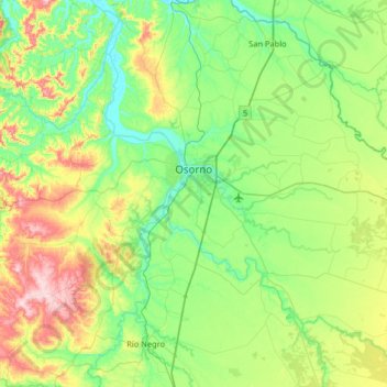
Nom : Carte topographique Osorno, altitude, relief.
Lieu : Osorno, Provincia de Osorno, Los Lagos Region, Chile (-40.78834 -73.41798 -40.41942 -72.76827)
Altitude moyenne : 105 m
Altitude minimum : 0 m
Altitude maximum : 393 m
Osorno's proximity to the Cardenal Antonio Samoré Pass makes it a key place the national economy. The mountain pass connects Osorno to the Argentine city of Bariloche, and is one of primary arteries that ties the two countries' southern regions together. The pass is particularly important due to the fact that it crosses the Andes mountains at very low altitude, allowing it to remain open even when other passes are blocked by snow.