
Faire un don
Équipez-vous pour votre prochaine aventure :
En tant que Partenaire Amazon, ce site perçoit une commission sur les achats éligibles sans surcoût pour vous.
Carte topographique Bali
Cliquez sur la carte pour afficher l’altitude.
Faire un don
Équipez-vous pour votre prochaine aventure :
En tant que Partenaire Amazon, ce site perçoit une commission sur les achats éligibles sans surcoût pour vous.
À propos de cette carte
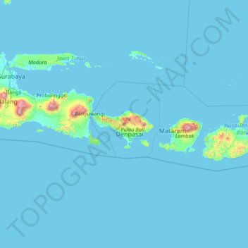
Nom : Carte topographique Bali, altitude, relief.
Lieu : Bali, Indonesia (-10.89050 112.53064 -5.77050 117.65064)
Altitude moyenne : 48 m
Altitude minimum : -1 m
Altitude maximum : 3 395 m
Faire un don
Équipez-vous pour votre prochaine aventure :
En tant que Partenaire Amazon, ce site perçoit une commission sur les achats éligibles sans surcoût pour vous.
Autres cartes topographiques
Cliquez sur une carte pour visualiser sa topographie, son altitude et son relief.
Pulau Bali
Bali features a diverse topography shaped by a volcanic origin, which significantly influences its landscapes and climate. The island is dominated by a central mountain range that runs from west to east, with Mount Agung, reaching an elevation of approximately 10,308 feet, standing as the highest peak and a…
Altitude moyenne : 122 m
Denpasar
Denpasar is located at an elevation of 4 m (13 ft) above sea level. While the total area of 125.98 km2 or 2.18% of the total area of Bali Province. From the use of land, 2,768 hectares of land are paddy, 10,001 hectares are dry land, while the remaining land area is 9 hectares.
Altitude moyenne : 7 m
Faire un don
Équipez-vous pour votre prochaine aventure :
En tant que Partenaire Amazon, ce site perçoit une commission sur les achats éligibles sans surcoût pour vous.
Faire un don
Équipez-vous pour votre prochaine aventure :
En tant que Partenaire Amazon, ce site perçoit une commission sur les achats éligibles sans surcoût pour vous.
Faire un don
Équipez-vous pour votre prochaine aventure :
En tant que Partenaire Amazon, ce site perçoit une commission sur les achats éligibles sans surcoût pour vous.
CitraLand Waterpark Denpasar
Indonesia > Bali > Denpasar > Denpasar Barat > Padangsambian Kaja
Altitude moyenne : 56 m
Faire un don
Équipez-vous pour votre prochaine aventure :
En tant que Partenaire Amazon, ce site perçoit une commission sur les achats éligibles sans surcoût pour vous.
Faire un don
Équipez-vous pour votre prochaine aventure :
En tant que Partenaire Amazon, ce site perçoit une commission sur les achats éligibles sans surcoût pour vous.
Faire un don
Équipez-vous pour votre prochaine aventure :
En tant que Partenaire Amazon, ce site perçoit une commission sur les achats éligibles sans surcoût pour vous.
Pecatu
Pecatu is located in South Kuta District of the Badung Regency. It is at the western end of the Bukit Peninsula in south Bali, and has a hilly topography with limestone cliffs isolating small, short beaches that have been privately developed. Nusa Dua, on the opposite side of the peninsula, is flat and is a…
Altitude moyenne : 65 m
Faire un don
Équipez-vous pour votre prochaine aventure :
En tant que Partenaire Amazon, ce site perçoit une commission sur les achats éligibles sans surcoût pour vous.
Denpasar
Denpasar is located at an elevation of 4 m (13 ft) above sea level. While the total area of 127.78 km2 or 2.18% of the total area of Bali Province. From the use of land, 2,768 hectares of land are paddy, 10,001 hectares are dry land, while the remaining land area is 9 hectares.
Altitude moyenne : 7 m
Faire un don
Équipez-vous pour votre prochaine aventure :
En tant que Partenaire Amazon, ce site perçoit une commission sur les achats éligibles sans surcoût pour vous.
Penida Island
Indonesia > Bali > Nusa Penida
Nusa Penida (Balinese: ᬦᬸᬲᬧᭂᬦᬶᬤ, romanized: nusa pĕnida) is an island located near the southeastern Indonesian island of Bali, which forms a district of the same name in Klungkung Regency. The Badung Strait separates the island and Bali. The interior of Nusa Penida is hilly with a maximum…
Altitude moyenne : 104 m
Klungkung Regency
Topographically, the Klungkung Regency area has a variety of land surface heights. Based on its height, the Klungkung Regency area is dominated by hilly areas with an altitude of between 100–500 meters above sea level with an area of 227.48 km2 (87.83 sq mi) or 72.22% of the total area of Klungkung Regency,…
Altitude moyenne : 55 m
Faire un don
Équipez-vous pour votre prochaine aventure :
En tant que Partenaire Amazon, ce site perçoit une commission sur les achats éligibles sans surcoût pour vous.
Faire un don
Équipez-vous pour votre prochaine aventure :
En tant que Partenaire Amazon, ce site perçoit une commission sur les achats éligibles sans surcoût pour vous.
Penida Island
Indonesia > Bali > Klungkung Regency > Batukandik
Nusa Penida (Indonesian pronunciation: [nuˈsa pəˈnida]; Balinese: ᬦᬸᬲᬧᭂᬦᬶᬤ, romanized: nusa pĕnida) is an island located near the southeastern Indonesian island of Bali, which forms a district of the same name in Klungkung Regency. The Badung Strait separates the island and Bali. The…
Altitude moyenne : 104 m
Pulau Bali
Bali's central mountains include several peaks over 2,000 metres (6,600 feet) in elevation and active volcanoes such as Mount Batur. The highest is Mount Agung (3,031 m, 9,944 ft), known as the "mother mountain", which is an active volcano rated as one of the world's most likely sites for a massive eruption…
Altitude moyenne : 122 m
Faire un don
Équipez-vous pour votre prochaine aventure :
En tant que Partenaire Amazon, ce site perçoit une commission sur les achats éligibles sans surcoût pour vous.
Kelingking Beach
Indonesia > Bali > Klungkung Regency > Bunga Mekar > Karangdewa
Altitude moyenne : 76 m
Penida Island
Indonesia > Bali > Nusa Penida
Nusa Penida (Balinese: ᬦᬸᬲᬧᭂᬦᬶᬤ, romanized: Nusa Penida, lit. 'Penida Island') is an island located near the southeastern Indonesian island of Bali and a district of Klungkung Regency that includes the neighbouring small island of Nusa Lembongan and twelve even smaller islands. The Badung…
Altitude moyenne : 104 m
Faire un don
Équipez-vous pour votre prochaine aventure :
En tant que Partenaire Amazon, ce site perçoit une commission sur les achats éligibles sans surcoût pour vous.
Badung
Topographically, Badung Regency has a variety of land surface contours. In the southern region, the dominant land surface contour is the lowlands to the coastal areas. Meanwhile, the central region is dominated by lowlands which are then followed by the land surface contours of hills and mountains in the…
Altitude moyenne : 208 m
Faire un don
Équipez-vous pour votre prochaine aventure :
En tant que Partenaire Amazon, ce site perçoit une commission sur les achats éligibles sans surcoût pour vous.
Pecatu
Pecatu is located in South Kuta District of Badung Regency. It is at the western end of the Bukit Peninsula in south Bali, and has a hilly topography with limestone cliffs isolating small, short beaches that have been privately developed. Nusa Dua, on the opposite side of the peninsula, is flat and is a…
Altitude moyenne : 78 m
Faire un don
Équipez-vous pour votre prochaine aventure :
En tant que Partenaire Amazon, ce site perçoit une commission sur les achats éligibles sans surcoût pour vous.
Faire un don
Équipez-vous pour votre prochaine aventure :
En tant que Partenaire Amazon, ce site perçoit une commission sur les achats éligibles sans surcoût pour vous.
Faire un don
Équipez-vous pour votre prochaine aventure :
En tant que Partenaire Amazon, ce site perçoit une commission sur les achats éligibles sans surcoût pour vous.
Faire un don
Équipez-vous pour votre prochaine aventure :
En tant que Partenaire Amazon, ce site perçoit une commission sur les achats éligibles sans surcoût pour vous.
Penida Island
Indonesia > Bali > Klungkung Regency > Batukandik
Nusa Penida (Balinese: ᬦᬸᬲᬧᭂᬦᬶᬤ, romanized: nusa pĕnida) is an island located near the southeastern Indonesian island of Bali, which forms a district of the same name in Klungkung Regency. The Badung Strait separates the island and Bali. The interior of Nusa Penida is hilly with a maximum…
Altitude moyenne : 104 m
Faire un don
Équipez-vous pour votre prochaine aventure :
En tant que Partenaire Amazon, ce site perçoit une commission sur les achats éligibles sans surcoût pour vous.
Faire un don
Équipez-vous pour votre prochaine aventure :
En tant que Partenaire Amazon, ce site perçoit une commission sur les achats éligibles sans surcoût pour vous.
Tabanan
Jatiluwih is an administrative village in Penebel District, north of Tabanan; it is formed with two customary villages, Gunung Sari and Jatiluwih; under these two customary villages there are seven customary hamlets or banjar. The village is at an altitude of 700 meters. Two routes to Jatiluwih are Denpasar >…
Altitude moyenne : 219 m
Faire un don
Équipez-vous pour votre prochaine aventure :
En tant que Partenaire Amazon, ce site perçoit une commission sur les achats éligibles sans surcoût pour vous.
Denpasar
Denpasar is located at an elevation of 4 m (13 ft) above sea level. While the total area of 125.98 km2 or 2.18% of the total area of Bali Province. From the use of land, 2,768 hectares of land are paddy, 10,001 hectares are dry land, while the remaining land area is 9 hectares.
Altitude moyenne : 7 m
Faire un don
Équipez-vous pour votre prochaine aventure :
En tant que Partenaire Amazon, ce site perçoit une commission sur les achats éligibles sans surcoût pour vous.
Buleleng
Buleleng Regency, located in the north of Bali Island, has a very diverse topography, consisting of lowlands, hills, and mountains. Most of the Buleleng Regency area is a hilly and mountainous area stretching in the south, while in the north, namely along the coast, is a lowland. These unique conditions make…
Altitude moyenne : 99 m
Faire un don
Équipez-vous pour votre prochaine aventure :
En tant que Partenaire Amazon, ce site perçoit une commission sur les achats éligibles sans surcoût pour vous.
Faire un don
Équipez-vous pour votre prochaine aventure :
En tant que Partenaire Amazon, ce site perçoit une commission sur les achats éligibles sans surcoût pour vous.