
Carte topographique Lysolaje
Carte interactive
Cliquez sur la carte pour afficher l’altitude.
À propos de cette carte
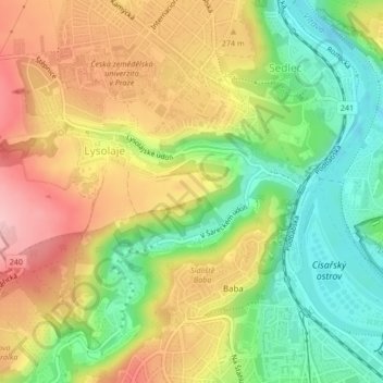
Nom : Carte topographique Lysolaje, altitude, relief.
Lieu : Lysolaje, Prague, Tchéquie (50.11189 14.35564 50.13157 14.38987)
Altitude moyenne : 245 m
Altitude minimum : 168 m
Altitude maximum : 326 m
Autres cartes topographiques
Cliquez sur une carte pour visualiser sa topographie, son altitude et son relief.
Pražský Hrad
Pražský Hrad, Jiřská, Hradčany, Prague, 11900, Tchéquie
Altitude moyenne : 237 m
Dolní Chabry
Dolní Chabry, Prague, okres Hlavní město Praha, Hlavní město Praha, Prague, 18400, Tchéquie
Altitude moyenne : 299 m
Vieille Ville
Vieille Ville, Prague, okres Hlavní město Praha, Hlavní město Praha, Prague, Tchéquie
Altitude moyenne : 216 m
Horní Počernice
Horní Počernice, Prague, okres Hlavní město Praha, Hlavní město Praha, Prague, 19300, Tchéquie
Altitude moyenne : 265 m
Malá Strana
Malá Strana, Prague, okres Hlavní město Praha, Hlavní město Praha, Prague, Tchéquie
Altitude moyenne : 233 m