
Carte topographique Stellenbosch
Carte interactive
Cliquez sur la carte pour afficher l’altitude.
À propos de cette carte
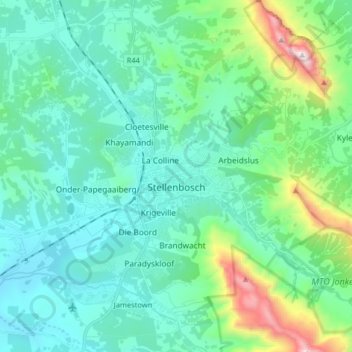
Nom : Carte topographique Stellenbosch, altitude, relief.
Altitude moyenne : 287 m
Altitude minimum : 36 m
Altitude maximum : 1 364 m
Stellenbosch is 53 km (33 mi) east of Cape Town via National Route N1. Stellenbosch is in a hilly region of the Cape Winelands, and is sheltered in a valley at an average elevation of 136 m (446 ft), flanked on the west by Papegaaiberg (Afrikaans: Parrot Mountain), which is actually a hill. To the south is Stellenbosch Mountain; to the east and southeast are the Jonkershoek, Drakenstein, and Simonsberg mountains. Die Tweeling Pieke (Afrikaans: The Twin Peaks) has an elevation of 1,494 m (4,902 ft); the highest point is Victoria Peak 1,590 m (5,220 ft). Jonkershoek Nature Reserve lies about 9 km (5.6 mi) east of Stellenbosch, and the Helderberg Nature Reserve is about 23 km (14 mi) south via provincial route R44. Just south of the Helderberg Nature Reserve is Strand, a seaside resort town. The soils of Stellenbosch range from dark alluvium to clay. This, combined with the well-drained, hilly terrain and Mediterranean climate, prove excellent for viticulture. Summers are dry and warm to hot, with some February and March days rising to over 40 °C (104 °F). Winters are cool, rainy and sometimes quite windy, with daytime temperatures averaging 16 °C (61 °F). Snow is usually seen a couple of times in winter on the surrounding mountains. Spring and autumn are colder seasons, when daytime temperatures hover in the 20s.
Autres cartes topographiques
Cliquez sur une carte pour visualiser sa topographie, son altitude et son relief.
Franschhoek
South Africa > Western Cape > Cape Winelands District Municipality > Stellenbosch Local Municipality
Franschhoek, Stellenbosch Local Municipality, Cape Winelands District Municipality, Western Cape, 7690, South Africa
Altitude moyenne : 502 m
La Motte
South Africa > Western Cape > Cape Winelands District Municipality > Stellenbosch Local Municipality
La Motte, Stellenbosch Ward 3, Stellenbosch Local Municipality, Cape Winelands District Municipality, Western Cape, South Africa
Altitude moyenne : 315 m
Groot-Drakenstein
South Africa > Western Cape > Cape Winelands District Municipality > Stellenbosch Local Municipality
Groot-Drakenstein, Stellenbosch Local Municipality, Cape Winelands District Municipality, Western Cape, 7680, South Africa
Altitude moyenne : 173 m
Driekop
South Africa > Western Cape > Cape Winelands District Municipality > Stellenbosch Local Municipality
Driekop, Stellenbosch Local Municipality, Cape Winelands District Municipality, Western Cape, South Africa
Altitude moyenne : 557 m
MTO Jonkershoek
South Africa > Western Cape > Cape Winelands District Municipality > Stellenbosch Local Municipality
MTO Jonkershoek, Jonkershoek Road, Stellenbosch Ward 5, Stellenbosch Local Municipality, Cape Winelands District Municipality, Western Cape, South Africa
Altitude moyenne : 522 m
Berg River Dam
South Africa > Western Cape > Cape Winelands District Municipality > Stellenbosch Local Municipality
Berg River Dam, Stellenbosch Local Municipality, Cape Winelands District Municipality, Western Cape, South Africa
Altitude moyenne : 376 m
Groendal
South Africa > Western Cape > Cape Winelands District Municipality > Stellenbosch Local Municipality
Groendal, Stellenbosch Local Municipality, Cape Winelands District Municipality, Western Cape, 7690, South Africa
Altitude moyenne : 353 m
Klapmuts
South Africa > Western Cape > Cape Winelands District Municipality > Stellenbosch Local Municipality
Klapmuts, Stellenbosch Local Municipality, Cape Winelands District Municipality, Western Cape, South Africa
Altitude moyenne : 186 m