
Faire un don
Équipez-vous pour votre prochaine aventure :
En tant que Partenaire Amazon, ce site perçoit une commission sur les achats éligibles sans surcoût pour vous.
Carte topographique Chelsea
Cliquez sur la carte pour afficher l’altitude.
Faire un don
Équipez-vous pour votre prochaine aventure :
En tant que Partenaire Amazon, ce site perçoit une commission sur les achats éligibles sans surcoût pour vous.
Chelsea
The topography of Chelsea consists primarily of coastal lowlands, punctuated by four drumlins formed during the last Ice Age. These drumlins are located in the southwest (Admirals Hill), southeast (Mount Bellingham), northeast (Powderhorn Hill) and northwest (Mount Washington). A smaller drumlin (Mill Hill) is located on the east side of Chelsea, adjacent to Mill Creek. This sloped and hilly landscape helps to divide the city into discernible neighborhoods, each with its own character, thereby giving the city a manageable sense of scale and orientation.
Faire un don
Équipez-vous pour votre prochaine aventure :
En tant que Partenaire Amazon, ce site perçoit une commission sur les achats éligibles sans surcoût pour vous.
À propos de cette carte
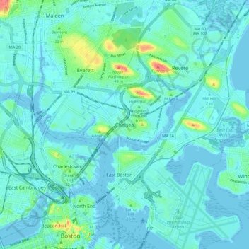
Nom : Carte topographique Chelsea, altitude, relief.
Lieu : Chelsea, Suffolk County, Massachusetts, 02150, United States (42.35122 -71.07693 42.43122 -70.99693)
Altitude moyenne : 8 m
Altitude minimum : -5 m
Altitude maximum : 56 m
Faire un don
Équipez-vous pour votre prochaine aventure :
En tant que Partenaire Amazon, ce site perçoit une commission sur les achats éligibles sans surcoût pour vous.