Géolocaliser

Carte topographique Bad Liebenstein

Carte interactive

Cliquez sur la carte pour afficher l’altitude.

À propos de cette carte

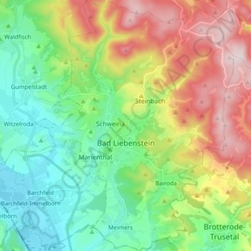
Nom : Carte topographique Bad Liebenstein, altitude, relief.

Lieu : Bad Liebenstein, Wartburgkreis, Thuringia, Germany (50.77870 10.29678 50.87039 10.41205)

Altitude moyenne : 424 m

Altitude minimum : 239 m

Altitude maximum : 748 m

Autres cartes topographiques

Cliquez sur une carte pour visualiser sa topographie, son altitude et son relief.

Ramsberg

Germany > Thuringia > Wartburgkreis > Lauterbach

Ramsberg, Lauterbach, Hainich-Werratal, Wartburgkreis, Thuringia, 99826, Germany

Altitude moyenne : 324 m

Bad Salzungen

Germany > Thuringia > Wartburgkreis

Bad Salzungen, Wartburgkreis, Thuringia, Germany

Altitude moyenne : 347 m

Gerstungen

Germany > Thuringia > Wartburgkreis

Gerstungen, Wartburgkreis, Thuringia, 99834, Germany

Altitude moyenne : 302 m

Walkes

Germany > Thuringia > Wartburgkreis > Geisa

Walkes, Geisa, Wartburgkreis, Thuringia, Germany

Altitude moyenne : 487 m

Eisenach

Germany > Thuringia > Wartburgkreis

Eisenach, Wartburgkreis, Thuringia, 99817, Germany

Altitude moyenne : 298 m