
Carte topographique Village of Silver Creek
Carte interactive
Cliquez sur la carte pour afficher l’altitude.
À propos de cette carte
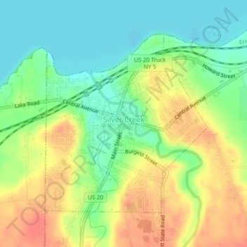
Nom : Carte topographique Village of Silver Creek, altitude, relief.
Altitude moyenne : 194 m
Altitude minimum : 170 m
Altitude maximum : 223 m
Autres cartes topographiques
Cliquez sur une carte pour visualiser sa topographie, son altitude et son relief.
Gurnsey Benchmark
United States > New York > Chautauqua County
Gurnsey Benchmark, Town of Carroll, Chautauqua County, New York, United States
Altitude moyenne : 618 m
Town of Villenova
United States > New York > Chautauqua County
Town of Villenova, Chautauqua County, New York, United States
Altitude moyenne : 452 m
Ashville
United States > New York > Chautauqua County
Ashville, Town of North Harmony, Chautauqua County, New York, 14710, United States
Altitude moyenne : 429 m
Mount Baldy
United States > New York > Chautauqua County
Mount Baldy, Town of Westfield, Chautauqua County, New York, 14787, United States
Altitude moyenne : 368 m
Town of Arkwright
United States > New York > Chautauqua County > Town of Arkwright
Town of Arkwright, Chautauqua County, New York, United States
Altitude moyenne : 451 m
Village of Fredonia
United States > New York > Chautauqua County
Village of Fredonia, Town of Pomfret, Chautauqua County, New York, 14063, United States
Altitude moyenne : 227 m
Ellicott
United States > New York > Chautauqua County
Ellicott, Chautauqua County, New York, United States
Altitude moyenne : 449 m
Cassadaga
United States > New York > Chautauqua County > Cassadaga
Cassadaga, Chautauqua County, New York, United States
Altitude moyenne : 418 m