
Faire un don
Équipez-vous pour votre prochaine aventure :
En tant que Partenaire Amazon, ce site perçoit une commission sur les achats éligibles sans surcoût pour vous.
Carte topographique Dahmsdorf
Cliquez sur la carte pour afficher l’altitude.
Faire un don
Équipez-vous pour votre prochaine aventure :
En tant que Partenaire Amazon, ce site perçoit une commission sur les achats éligibles sans surcoût pour vous.
À propos de cette carte
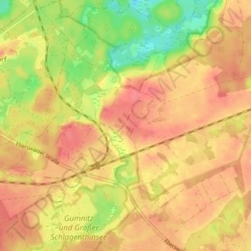
Nom : Carte topographique Dahmsdorf, altitude, relief.
Altitude moyenne : 54 m
Altitude minimum : 14 m
Altitude maximum : 77 m
Faire un don
Équipez-vous pour votre prochaine aventure :
En tant que Partenaire Amazon, ce site perçoit une commission sur les achats éligibles sans surcoût pour vous.
Autres cartes topographiques
Cliquez sur une carte pour visualiser sa topographie, son altitude et son relief.
Maxsee
Deutschland > Brandenburg > Märkisch-Oderland > Müncheberg > Maxseesiedlung
Laut Datenerhebung des Instituts für angewandte Gewässerökologie Brandenburg aus dem Jahr 2001 ergeben sich folgende topographische, morphometrische und limnologische Werte für den Maxsee: die maximale Tiefe des Gewässers beträgt vier, die mittlere Tiefe rund zwei Meter. Der von Nordost nach Südwest…
Altitude moyenne : 52 m